Deep freeze to cause major temperature swings, with lows that could break records in the South
The calendar still says fall, but the atmosphere is skipping ahead to winter as a rush of Arctic air sends more than two dozen states into a brief deep freeze.
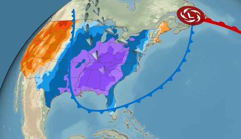
It all starts this weekend in the Midwest, where temperatures will drop 10 to 20 degrees below average, making it feel more like December from the Dakotas to Missouri. The shivering conditions could allow the first snowflakes of the season to fall in parts of the Midwest, while also turning on the lake-effect snow machine in the Great Lakes.
These winter-like conditions — with the coldest temperatures of the season — will reach as far south as Florida while also spreading to the East Coast early next week. More than 20 locations in the Southeast could wake-up to record cold temperatures Tuesday morning.
Here’s how this chilly change-up will play out.
Parts of the northern Plains and the Upper Midwest will be first in line for plummeting temperatures starting Saturday. This temperature drop could also be accompanied by a mix of snow and rain from the Dakotas to southern Minnesota and northern Iowa.
Minneapolis will wake up to wind chills in the lower teens by Sunday morning; the actual air temperature will struggle to reach the freezing mark. That’s on par with the average high for December 6.
Sunday will begin with low temperatures in the 20s or lower for much of the central US and stay frigid. Temperatures could end up 10 to 20 degrees below average for much of the Plains, Midwest and portions of the Ohio and Tennessee valleys.
The high temperature in Chicago will likely struggle to reach the mid-30s Sunday, which is about 15 degrees colder than normal. St. Louis will be 15 degrees colder than it should be with a high near 40 degrees.
Monday morning will be the coldest since spring for tens of millions of people east of the Rockies and dip even cooler, threatening several record lows, by Tuesday morning. Low temperatures at or below freezing – 32 degrees – are possible as far south as Texas and as far east as the Appalachians.
Buffalo, New York, could drop into the 20s on Monday morning and only reach the mid-30s by the afternoon. A normal early November high for the city is about 50 degrees.
Monday will likely be the coldest day of the wintry blast for much of the eastern two-thirds of the US, but the Southeast will be the epicenter for some of the coldest air relative to normal.
Monday will also feature a dramatic temperature drop for Atlanta. Sunday’s high in the city is expected to be near 70 degrees, but temperatures will struggle to reach the mid-40s on Monday. Temperatures could tumble to the upper 20s by Tuesday morning, which could end up being Atlanta’s coldest morning since February.
Daily record lows temperatures could be threatened Tuesday morning in parts of Alabama, Mississippi, Georgia, southeast Louisiana and Florida. That includes Birmingham and Huntsville, Alabama; Baton Rouge, Louisiana; Savannah, Georgia; and Tampa and Fort Myers, Florida.
While not at record cold levels, much of the East will remain quite chilly on Tuesday. It’s likely to be the coldest morning of the stretch for Washington, DC, and New York City. Low temperatures in both cities could be right around the freezing mark, with morning wind chills down in the lower to mid-20s.
This cold snap won’t stick around long though: Temperatures in much of the central US will quickly rebound to near or even above normal on Tuesday and most of the East will follow suit on Wednesday.
The blast of Arctic air could set up some places to get their first snow event of the year.
The typical snow belts downwind of the Great Lakes are so far the most likely to see accumulating snow later this weekend into next week, with lake-effect possible after the cold front swings over the lakes on Sunday. Some snow could accumulate in Indiana, Michigan, Ohio, Pennsylvania and New York through Monday night.
There’s also the possibility for snow in other parts of the Midwest this weekend. Chicago, Milwaukee and Rochester, Minnesota, are among the places that could see a mix of rain and snow or get their first proper snowflakes of the season, though little – if any – accumulation is expected.
Snowflakes could even fly through the air as far south as the Ohio and Tennessee valleys by Monday. Higher elevations of the Appalachians will see accumulating snow from West Virginia to border between North Carolina and Tennessee.