Arctic blast to plunge parts of Eastern US to record cold. Is the polar vortex to blame? Here’s what we know.
Our first true shot of winter arrives late Sunday and spills into the first half of next week. I’m not talking about snow. Instead, a shot of Arctic air will plunge south into the United States from Canada and migrate east over New England.
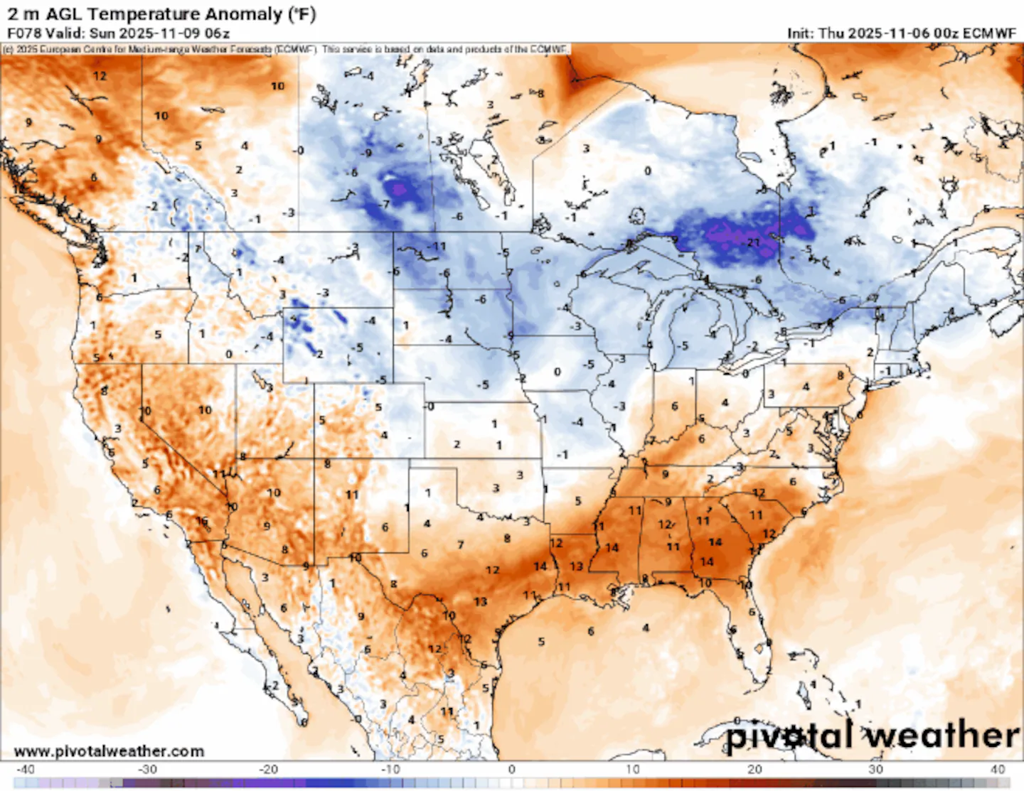
Temperatures are forecast to drop as much as 20 to 30 degrees below normal for Florida and the rest of the Southeast, which is forecast to reach record lows, the Mid-Atlantic, and portions of the Plains Sunday through Tuesday evening. New England can expect temperatures to drop as much as 10 degrees below normal, not nearly as intense as other parts of the country, but still noticeable.
For our region, the cold snap will be brief, with temperatures rebounding by the end of next week. Greater Boston and most of New England may see a couple of daily highs held to the mid-40s and overnight temperatures near freezing.
Freezing temperatures may reach as far south as the Gulf Coast, including Atlanta, Tallahassee, and Jacksonville, Fla. — not much fun for those hoping to enjoy a long weekend or vacation in the Sunshine State.
Arctic air will progress into the eastern half of the country to end the weekend and through the start of next week.Tropical Tidbits
Is the polar vortex behind all this bitter cold?
You will see multiple news outlets and people across social media blame the polar vortex for the cold air — that’s not the case here. The answer may surprise you!
Yes, the frigid air has originated from the Arctic region of Northern Canada, but it is not actually the polar vortex that’s behind this mass of cold air. The polar vortex is a large area of low pressure and cold air surrounding the Earth’s poles, held together by a band of strong winds high up in the stratosphere. These winds usually strengthen during the wintertime, but if slowed down enough, lobes of cold air can break away and migrate south of the country, bringingfrigid temperatures to millions.
A stable polar vortex keeps Arctic air up near the North Pole.Boston Globe
Here’s a look at a disrupted polar vortex, below, with pockets of extensively polar, cold air slipping into the U.S. This happens when the winds slow down and pockets of polar air break away from the counter-clockwise flow of air.
A disrupted polar vortex will send pockets of Arctic air south into the United States.Boston Globe
This shot of freezing air is due to a piece of the less-understood and less popular tropopause polar vortex, or TPV for short. This has paired with a strong high-pressure ridge across the west that will send a deep cold front and trough across the east, basically opening the door for this pocket of cold air to waltz right in. More on this below, but let’s take a look at what is unfolding.
See the orange-red blob over Greenland, below? That’s a classic atmospheric blocking pattern, or simply put, a strong high-pressure system.
The shot of cold, Arctic air, in blue, will be forced south because it simply cannot advance east against the more dense high over Greenland. And the strong high-pressure ridge across the western U.S. will open the door for the frigid air to race south to the Gulf.
Arctic air will progress into the eastern half of the country to end the weekend and through the start of next week.Tropical Tidbits
The polar vortex lives high in the atmosphere, in the stratosphere. Weather occurs in the troposphere, the lowest layer of the atmosphere where we live.
The TPV circulates the globe year-round, linking what is happening in the stratosphere to the weather we experience at the surface. How does this happen? By simply sinking into the atmosphere, closer to the surface. The jet stream and lower surface patterns scoop up this cold air and move it along.
It is much more localized than the jet stream, but it simply acts as a conduit between the polar vortex and weather features at the surface.
That’s what we’re experiencing. We separate the polar vortex into two parts because they play different roles. But like gears to a watch, they work together and influence our weather, especially during the winter.
The tropopause polar vortex (TPV) holds Arctic air versus the polar vortex, which is tightly bound by the poles.NOAA
Here’s a current look, below, of the polar vortex high up in the stratosphere. It is tightly bound to Greenland and Northern Canada. If we were to see air directly from the polar vortex, we would be talking significantly colder temperatures this weekend and into next week. It has happened before, and will likely happen again this winter, especially for parts of the interior Northeast.
The polar vortex will remain intact across the North Pole heading into next week.Polar Wx
It will be interesting heading into the second half of November as the winds holding the polar vortex are forecast to slow considerably, which could mean more pockets of cold air, and possibly from the true polar vortex, could descend into the county.
The polar vortex winds may slowly decrease in the next couple of weeks (thick blue line as forecast average).EURO Model
Sign up here for our daily Globe Weather Forecast that will arrive straight into your inbox bright and early each weekday morning.
Ken Mahan can be reached at ken.mahan@globe.com. Follow him on Instagram @kenmahantheweatherman.