Chicago could see historic double-digit November snow as an Arctic blast spreads across much of the US
Intense lake-effect snow is hammering Chicago Monday morning and creating dangerous travel conditions as a record November cold snap sends the eastern half of the US into a brief bout of winter.
A narrow, but extremely intense band of snow is dumping snow at a rate of 3 or more inches per hour – so fast it can overwhelm the city’s capacity to keep roads clear and create “dangerous to nearly impossible travel conditions,” according to the National Weather Service. It’s also produced thundersnow, wind gusts near 35 mph and near-zero visibility at its peak.
Snow accumulations could swing wildly block to block from a few inches to more than a foot based on the exact placement of the narrow band. If the band stalls over Chicago, double-digit snow could fall before midday Monday.
Chicago hasn’t had a 10-inch snow since January 2021; the last 10 inch November snow was in 2015; and the biggest November snowfall ever recorded in the city is 12 inches in 1895.
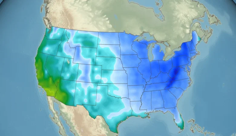
The snow threat stretches beyond Chicago across the Great Lakes, spawned by an unusually cold for November mass of Arctic air pushing south and east and threatening dozens of low temperature records as far south as Florida over the next couple of days.
In northwest Indiana, near Valparaiso, a trained weather spotter reported 6 inches of snow falling in just over 2 hours. Numerous reports and videos of thundersnow in downtown Chicago began to roll in after midnight local time.
This brutal setup in Chicago is being driven by the same Arctic air mass that’s about to crash across the eastern two-thirds of the country. This isn’t just a “cold front.” This is a full scale polar plunge.
Monday morning will be the coldest since spring for tens of millions east of the Rockies, and it gets even colder into Tuesday. Low temperatures at or below freezing are possible as far south as Texas and Florida and as far east as the Appalachians.
Atlanta does one of the most dramatic temperature flip-flops. Sunday’s high there was near 70. Monday, the city will struggle to reach the upper 30s. Temperatures could tumble into the upper 20s by Tuesday morning, which would be Atlanta’s coldest morning since February. We would expect to see temperatures like this in mid-January, not during the first half of November.
Daily record lows could be threatened Tuesday morning across parts of Alabama, Mississippi, Georgia, southeast Louisiana and even Florida. That includes places like Birmingham and Huntsville in Alabama, Baton Rouge in Louisiana, Savannah in Georgia and Tampa and Fort Myers in Florida.
Washington, DC, and New York City are also likely to log their coldest morning of the stretch on Tuesday. DC could wake up near 30. New York only reaches a high in the mid-40s Tuesday afternoon. Morning wind chills in both cities could sit in the lower to mid-20s, but Chicago’s setup is uniquely volatile because of how the Arctic air is interacting with the warm lake.
There will be snow in other regions as well — it just won’t look like Chicago’s concentrated burst. Lake-effect snow continues downwind of the Great Lakes. The west slopes of the central Appalachians could pick up several inches Monday. Higher elevations from West Virginia through the border of North Carolina and Tennessee can expect accumulating snow.
The good news: The cold snap won’t stick around long. Temperatures across the central US rebound quickly on Tuesday, and most of the East warms up again on Wednesday.