Chicago Pounded By Lake-Effect Snow; More Through Tuesday In Great Lakes, Northeast, Appalachians
Snow Could Be Measured In Feet
The first snow of the season has been impacting parts of the Midwest and Great Lakes, including some heavy lake-effect snowbands. While the snowfall here is diminishing, parts of the Appalachians, upstate New York and northern New England will see snow linger into Tuesday.
This snowy forecast is all because of a potent, but brief, cold outbreak in the Midwest, South and East. For more on the cold forecast details, check out our forecast here.
Happening Now
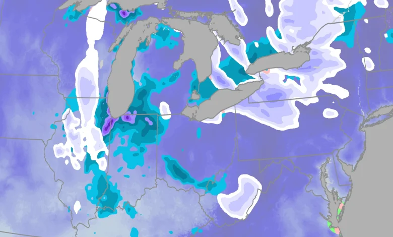
The map below shows where snow is currently falling across parts of the eastern United States.
The heaviest additional accumulations will likely be in the lake snowbelts from northwest Pennsylvania and southwest New York, south of Buffalo, to upstate New York’s Tug Hill Plateau, the Green Mountains of northern Vermont and Appalachians of West Virginia. Over 6 inches of snow is possible in these areas.
The heaviest snowfall has ended in the western Great Lakes snowbelts from Michigan and Indiana as well as the Smoky Mountains, but what little is falling could still bring an additional inch or so to these regions.
Alerts
The map below shows where winter storm or lake-effect snow warnings (dark color) or advisories (lighter color) have been issued by the National Weather Service.
What’s Happened So Far:
Up to 12 inches of snow fell in just 6 hours within one intense snowband over the town of Momence, Illinois, about 50 miles south of downtown Chicago.
Chicago’s O’Hare Airport picked up 1.7 inches of snow through early Monday morning, while 6 to 7 inches of snow was reported from the northern suburb of Wadsworth, Illinois.
Accompanying the snow, occasional lightning was seen over Chicagoland overnight Sunday night into Monday morning, with winds gusting to 50 mph along the lakeshore downtown.
Parts of northern Indiana from the Chicago suburbs to South Bend have already picked up 4 to 14 inches of snowfall. Numerous vehicle accidents were reported across Indiana, including the Indianapolis metro.
Elsewhere, up to 18 inches of snow was reported south of Marquette, Michigan, and up to 10 inches of snow was reported in Lower Michigan’s Leelanau Peninsula north of Traverse City.
Parts of extreme southeast Wisconsin’s Racine and Kenosha Counties measured up to 13 inches of lake-effect snow. Just across the border, 15 inches of fluffy snow piled up in Winthrop Harbor, Illinois.
Generally 2 to 5 inches of snow has also been reported in the eastern Cleveland and Detroit metros, so far. Parts of central and western Ohio picked up 1 to 4 inches, and a few higher elevation locations in the Smoky Mountains have picked up 3 inches of snow.
Over the weekend, up to 5 inches of snow fell over parts of northwest Iowa and southeast South Dakota.
(MORE: What November Weather Is Typically Like)
Take It Slow
As this is the first snow of the season for many of these areas, allow extra time to travel, slow down and leave extra distance between you and the vehicle in front of you.
Also, keep in mind even if any light snow melts on pavement, this wet pavement could freeze by the evening as the air cools. This could lead to slippery spots, especially over bridges and overpasses.
(MORE: What November Weather Is Typically Like)
How Early Is This First Snow?
For many of the areas in this forecast, their first accumulating snow — at least 0.1 inch — of the season usually happens in November.
That includes Buffalo (Nov. 8), Chicago (Nov. 18) and Detroit (Nov. 19), according to NOAA 30-year averages.
This “first snow” is a tad late in parts of the Northern Plains. Bismarck, North Dakota, usually sees their first 0.1 inch of snowfall by Oct. 28, and was about 4 inches behind their average seasonal snowfall pace before snow fell last Friday night.
(MORE: When You Typically See Your First Snow)
Month of the average first accumulating (0.1 inches or greater) snowfall of the season, according to 30-year average statistics.
(Data: NOAA)
What are your thoughts about seeing snow in the forecast? Leave us a reaction and a comment below. We’d love to hear from you.
Jonathan Erdman is a senior meteorologist at weather.com and has been covering national and international weather since 1996. Extreme and bizarre weather are his favorite topics. Reach out to him on Bluesky, X (formerly Twitter) and Facebook.