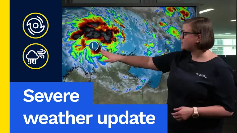
The first tropical cyclone of the 2025–2026 Tropical Cyclone season is likely to develop this week to the north of the Northern Territory. We can see it starting to develop now looking at our satellite imagery. We can see quite a lot of cloud and thunderstorm activity wrapping around this low-pressure system, you can see here. That this Tropical Low 02U.
And it’s this system which may intensify to reach Tropical Cyclone status over the next few days. We’ve already seen quite a lot of rain, showers and storms pushing across the Top End over the last few days. Some of that has been associated with this developing, deepening Tropical Low. So how will things play out over the next couple of days?
Well, through the rest of today and into Wednesday, we are likely to see this tropical low pressure system slowly moving towards the east. Now, the strongest winds that you can see wrapping around this low-pressure system, and the heaviest rain, are likely to be held a little way away from the Northern Territory coast. We are still expecting showers, thunderstorms and some gusty coastal winds over the next few days for the Northern Territory, but the heaviest of the impacts are likely to be closer to the system itself.
However, it’s at this point in time, late Wednesday going into Thursday morning, that we’re likely to see the risk of this system being a tropical cyclone increasing. Ahead of this risk, we have issued a Tropical Cyclone Track Map to give you a better indication of how this all may play out. Looking at the track map now, we’ve got the Northern Territory coastline down the bottom here and the likely path of this system.
Marked here with timestamps going from now, this blue one you can see, all the way out to around Friday morning. Now, for the next few days, we are expecting, as I said, this system to gradually move east-north-east. At this point in time, we are expecting a possible intensification to tropical cyclone strength by around Thursday morning. It’s at that time that we would officially name this system as a tropical cyclone, using the name Tropical Cyclone Fina.
From that point, the system may well drop to the south, possibly intensifying to a category two system. However, there are quite a range of forecast scenarios from Wednesday onwards regarding how the system will develop, how strong it might get, and where it will track. Some of those scenarios are expressed in our Tropical Cyclone Track Map.
This grey line you can see moving around here is the range of forecast tracks. This means by the end of the week, the centre of our low-pressure system or tropical cyclone could be located in the eastern part of this track-map range, or in the western part of this track-map range. Exactly where it will be located will determine exactly what impacts we can expect from this system.
Our tropical cyclone team will be keeping a close eye on this system as it continues to develop, and we will bring you regular updates over the next few days. One way or the other, though, we are expecting showers, rain and storms to continue for parts of the Top End over the coming days.
Rainfall totals are likely to be heaviest closest to the coast, with those top totals most likely about the Tiwi Islands and that north-west corner, including around the Darwin area. Again, the highest rainfall totals will be determined by where this tropical low, or possible tropical cyclone, eventually do track.
So, with this tropical cyclone likely to develop over the next few days, it’s essential you stay on top of the latest forecasts, warnings and track maps, which you can find via the Bureau’s website, the BOM Weather app and via our social media. Stay safe, and we’ll catch you next time.