PHOENIX — After rain speckled the Valley on Wednesday morning, a second round of rain splattered across the Valley — and brought crackling thunder, flashing lightning and heavy hail with it.
The National Weather Service (NWS) warned that a severe storm was moving into metro Phoenix around 4 p.m.
It was especially severe in the West Valley, according to Sean Benedict, a meteorologist with the NWS Phoenix office.
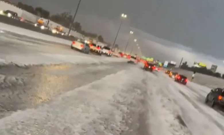
“In the West Valley, we have a pretty strong to severe thunderstorm moving through,” Benedict told KTAR News 92.3 FM around 5 p.m. “The main impact has been a lot of accumulating small hail and very intense rainfall, and, so, we’ve been seeing some videos of streets and even highways with accumulated hail on the road, causing slowdowns.”
The storm in the West Valley has been producing a lot of accumulating small hail. Please be careful and slow down on the roadways as conditions may be very slick. #azwx https://t.co/IkGBvuc6oU
— NWS Phoenix (@NWSPhoenix) November 20, 2025
“It almost looks like snow, but it’s not snow. It’s just hail,” Benedict said. “But, yeah, a pretty intense storm moving through the West Valley at the moment.”
Large swaths of the West Valley were also issued a severe thunderstorm warning, with winds of up to 50 mph and quarter-sized hail possible in Sun City, Peoria, Glendale and Tolleson.
Watch the storm coming in: Patricia Valencia, one of our @BroomheadShow producers, captured this video. ⛈️ @PattyCakes_713 pic.twitter.com/wBYQRhPsip
— KTAR News 92.3 (@KTAR923) November 20, 2025
“There’s still a few other storms down to the southwest, mainly moving towards the west and central part of the Phoenix area,” Benedict said.
One those storms started to make its way into the southeast Valley near the Ahwatukee area around 6:16 p.m. It dropped hail on Loop 202 South Mountain Freeway near 24th Street.
6:32 PM MST: Accumulating hail confirmed via ADOT camera along 202 Loop South at 24 St. Drive with Caution! pic.twitter.com/7Ypew6SCX9
— NWS Phoenix (@NWSPhoenix) November 20, 2025
NWS radar then showed the storm moving north through the Tempe and Scottsdale area.
The weather authority said the storm was moving over the Fountain Hills area around 7:25 p.m. and was likely to continue producing hail.
Flash flood warnings were issued for multiple parts of the Valley as the storms moved through, including Glendale, Peoria, Avondale, Sun City, Anthem, New River and Rock Springs.
Additionally, a flood watch is in effect for most of Yavapai County and northwestern Maricopa County through Wednesday evening, and for northeastern Maricopa County through Thursday morning.
Benedict advised drivers to slow down if they see any flooded roads. Several people have been put in danger due to flooding over the past day, including four people in Wickenburg who required rescues on Tuesday.
“For the next couple of hours, we’re going to continue to see showers move through, although as we head into the overnight hours, some of the thunderstorm potential is going to lower a little bit,” Benedict said.
“Still can’t rule out an isolated shower thunderstorm here or there, but a lot of the activity is going to start to shift its focus more towards the east and southeast Valley and maybe more towards even just east of the Phoenix area.”
KTAR News 92.3 FM’s Anna Olp contributed to this report.
We want to hear from you.
Have a story idea or tip? Pass it along to the KTAR News team here.