The Winter Storm Watch that started with just a handful of counties in the western Upper Peninsula has now spread across the U.P. and dipped down into some of our traditional snowbelt counties in the northern Lower Peninsula.
These storm watches – which caution about hazardous driving, high winds and more than 25 inches of snow in some areas – are being issued ahead of a powerful storm system forecast to start tomorrow in the top half of the state and be felt by Wednesday in West Michigan, Mid-Michigan and Southeast Michigan.
High wind gusts – reaching up to 60 mph in some areas – combined with snow are expected to make travel conditions difficult.
Wednesday’s high winds could also lead to power outages.
Upper Peninsula
Nearly all of western and central Upper Peninsula counties are now under a Winter Storm Watch. In most areas, this storm watch begins on Tuesday and lasts into Thanksgiving Day.
Snow totals are forecast to be quite high in some areas, with the Keweenaw Peninsula in line to get anywhere from 14 to 25 inches of snow.
And meteorologists at the National Weather Service office in Marquette are not mincing words about the impact this could have on travel on Tuesday, Wednesday and Thursday:
“Travel could be very difficult to impossible,” they said while issuing the storm watches. “Widespread blowing snow could significantly reduce visibility. The hazardous conditions will impact the Tuesday evening and Wednesday morning commutes as well as Thanksgiving holiday travel. Gusty winds could bring down tree branches.”
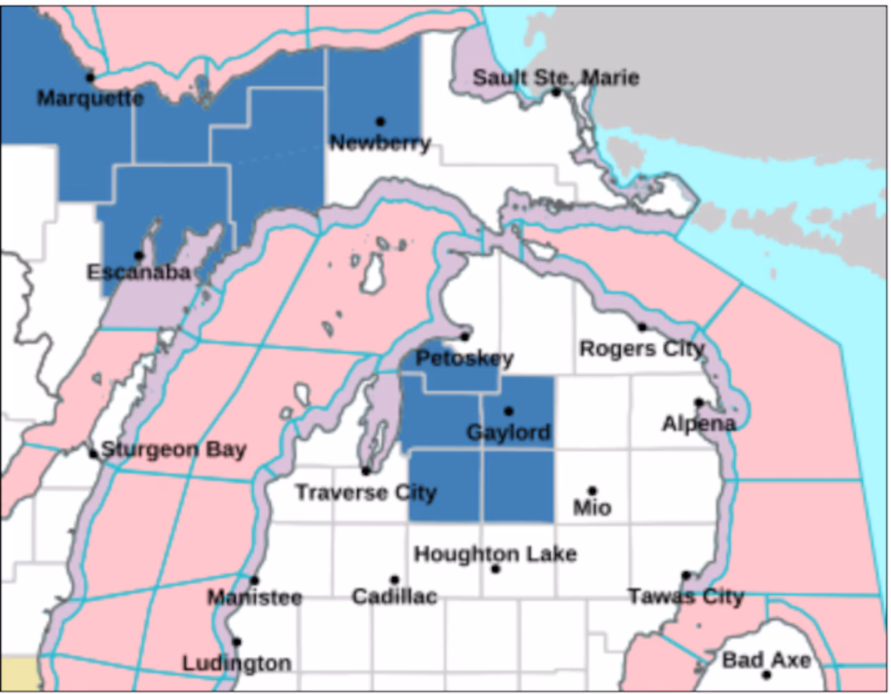
The Winter Storm Watch area ahead of the Thanksgiving storm system has expanded to include more of the Upper Peninsula and a section of the northern Lower Peninsula.Graphic provided by the National Weather Service
Northern Michigan/Lower Peninsula
Winter Storm Watches have now been issued for the heavy snowbelt areas in some of the northern Lower Peninsula counties.
Winter storm watches will be in effect from Wednesday afternoon through Friday morning for the counties of Antrim, Otsego, Kalkaska, Crawford and Charlevoix.
Both heavy accumulating snow and blowing snow are likely in this area. While 5 to 9 inches of snow are forecast, some areas could see 10 inches or more, the National Weather Service team in Gaylord said.
“Winds could gust as high as 45 mph. The combination of accumulating snow and significant drops in visibility will make hazardous holiday travel likely across parts of Northern Michigan.”
We do expect more storm watches – maybe even some storm warnings – to be issued as this storm gets closer to Michigan. You can stay updated on the latest weather coverage here.