Tuesday morning weather forecast
Rain is moving into North Georgia and thunderstorms are possible throughout the day although they are expected to be heavier later in day.
ATLANTA – If you’re hitting the road or flying out of Atlanta on Tuesday, prepare for delays. Two rounds of storms are expected to move through north and central Georgia on one of the busiest travel days of the year.
Rain, storms across Georgia on Tuesday
What they’re saying:
Rain began falling in North Georgia early Tuesday morning, and the first line of thunderstorms have already started moving into North Georgia.
8:10 A.M. UPDATE: Thunderstorm warnings extended into Fulton, DeKalb, Gwinnett, Fayette, Coweta, Clayton, and Henry. Line of storms still sustaining the potential for damaging wind gusts to 60mph.
7:55 A.M. UPDATE: A ground stop has been issued for Hartsfield-Jackson Atlanta International due to thunderstorms, according to FAA. It is currently in effect until 8:45 a.m.
7:45 A.M. UPDATE: New Severe Thunderstorm Warning issued for Paulding, Bartow, Cobb, Cherokee, Carroll, Douglas, Coweta, and Heard counties. Damaging winds are still expected with the line of storms moving in quickly from the west.
7:30 A.M. UPDATE: A severe thunderstorm warning was issued for northwest Georgia around 7:30 a.m. The fast-moving storm could produce damaging winds. The warning applies to Floyd, Haralson, Polk, Carroll, and portions of Chattooga, Paulding and Bartow.
TUESDAY WEATHER TIMELINE (ATLANTA METRO)
🌧️ 5–5:30 a.m. — Rain Begins, Umbrellas Needed
Scattered showers lift through the north metro, including Cherokee, Fulton, and Forsyth counties.
No storms or lightning yet — just pockets of moderate rain.
Temps near 61°F, noticeably warmer than Monday.
🌥️ 6–9 a.m. — Off-and-On Showers, Heavier Patches North & West
Rain increases around Bartow County and areas near Lake Lanier.
South side remains mostly dry early, but that won’t last.
Severe storms remain west of Georgia but are approaching quickly.
⛈️ Mid-Morning (9–11 a.m.) — Storm Risk Creeps In
Severe thunderstorm warnings pop up in Alabama; this is the “preview” of what may reach NW Georgia later.
Models suggest weather warnings possible locally after sunrise.
Rain stays scattered, but coverage slowly increases.
🌦️ Late Morning–Afternoon (11 a.m.–4 p.m.) — Waves of Showers & Isolated Storms
Showers and occasional thunderstorms move through the region.
Severe weather remains possible, but not widespread yet.
Temps climb into the low 70s, unusually warm for late November.
⛈️🌪️ Evening (4–8 p.m.) — Storms Pick Up, Highest Severe Risk
As the cold front approaches, storms become more widespread.
Metro Atlanta is under a Level 1 risk (damaging winds, hail, brief tornado possible).
Randolph & Cleburne counties (AL) under Level 2, with higher threats sliding toward Georgia.
⚡ After Sunset–Midnight (8 p.m.–12 a.m.) — Strongest Storm Window
Most intense weather during and after sunset.
Potential for damaging wind gusts or a brief spin-up tornado.
Heavy rain will be widespread — “everyone gets something.”
🌧️🌬️ Overnight (12–2 a.m.) — Front Moves Through
Storms finally push east of Atlanta after midnight.
Temperatures begin to fall behind the front.
🌤️ Wednesday Preview
Highs only in the 60s.
A second reinforcing front Wednesday night brings even colder air.
🦃 Thanksgiving Outlook
High near 50°F, dry but cold.
Black Friday Outlook
High near 40°F, the coldest day of the week.
ORIGINAL STORY
The second, stronger round of storms are expected to move through after sunset — between 5 and 9 p.m., sweeping across metro Atlanta and continuing east overnight.
“It is going to be a rough travel day here in the metro and at the airport,” Forbes said. “Atlanta is one of those problem spots, but it’s not going to be just us. From Pittsburgh down through Huntsville and over toward Nashville, we’re looking for significant delays through the Tuesday travel holiday.”
Along with storms in Atlanta, showers are also expected in New York, Chicago, and Washington, D.C., three of the nation’s busiest airline hubs — which could create ripple effects across the national flight network.
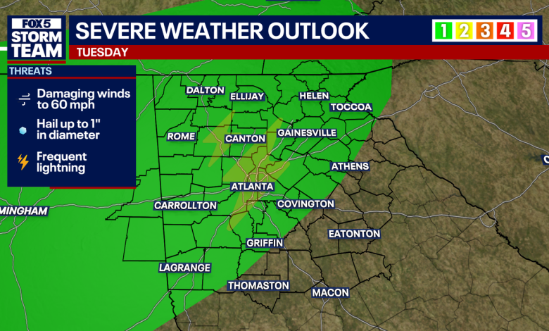
Locally, Georgia is under a Level 1 severe weather risk for Tuesday afternoon.
“It wouldn’t surprise me if when we wake up tomorrow morning, maybe that Level 2 risk in Alabama creeps into parts of west Georgia,” Forbes said. “The evening round has the better chance of seeing a stronger storm or two.”
Once the storms move out late Tuesday night, conditions will turn breezy and cooler.
Cooler, breezy after storms move out
What they’re saying:
“Wednesday is going to be windy — not as cool as it’s going to get just yet — but by the time you’re waking up on Thanksgiving morning, hello 30s,” Forbes said.
Thanksgiving Day will be cool and clear, with highs in the mid-50s, followed by another blast of cold air later in the week. By Friday, highs will struggle to reach 49 degrees, with light rain chances returning Sunday and Monday.
The Source: Information in this article came from the National Weather Service and FOX 5 Storm Team forecasts for Atlanta the week of Nov. 24, 2025.
Severe WeatherNewsHartsfield-Jackson Atlanta International AirportTravel NewsAtlantaHolidays