Wicked ‘weather bomb’ threatens power outages, floods and new November low-pressure record
St. John’s, N.L., is likely to set a low-pressure record for November. However, it will fall short of the all-time, low-pressure record set back on Feb. 11, 2003.
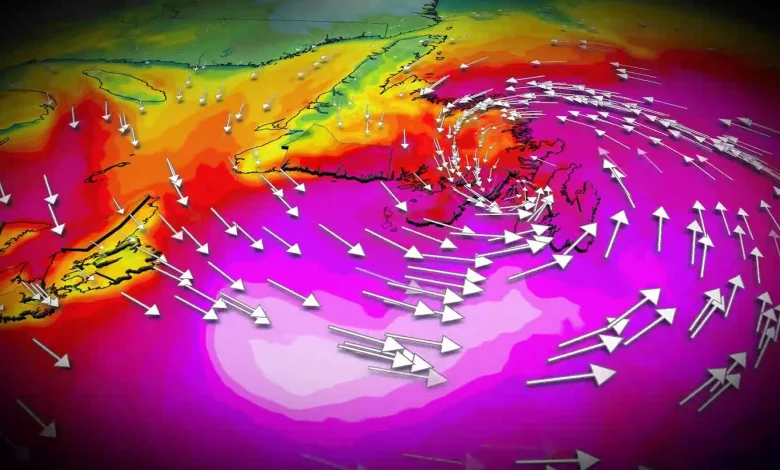
Sustained, southerly winds of 80 km/h are likely across southeastern Avalon by Tuesday evening, with gusts exceeding 120 km/h, becoming southwesterly late in the evening as the system lifts across the region. Wind warnings are in effect.
Peak wind gust projections on Tuesday:
The most recent gust that topped 100 km/h in St. John’s occurred on Feb. 15, while the last gust exceeding 110 km/h was recorded on Jan. 5.
DON’T MISS: Canada’s November features extended fall, but winter lurks on the sidelines
Localized flooding and coastal erosion a threat
The heaviest rainfall axis will be north of the track of the low, so Cape Breton, N.S., and central and western Newfoundland are forecast to see a widespread swath of 30-60 mm, with locally higher amounts possible.
Rainfall forecast:
Impacts may include power outages, downed trees, minor structural damage, localized flooding in Cape Breton and Newfoundland, as well as coastal erosion due to monster waves reaching 6-8 metres.
By Wednesday morning, the powerful low lifts northeast of the province, with winds gradually easing and precipitation becoming more scattered through the afternoon.
Stay updated as the storm progresses. Weather conditions will likely present risks for travel and infrastructure in the region.
WATCH: How a ‘weather bomb’ forms and what it means
Stay tuned to The Weather Network for the latest forecast updates for Atlantic Canada.