Updated December 18, 2025 — 3:33pm,first published December 18, 2025 — 10:26am
Save
You have reached your maximum number of saved items.
Remove items from your saved list to add more.
Save this article for later
Add articles to your saved list and come back to them anytime.
Got it
Melburnians are sweltering through the first heatwave of summer but preparing for an unseasonably cold Christmas day, as emergency warnings are issued for an out of control grass fire near Benalla.
The temperature hit a top of 38.3 degrees at Melbourne’s Olympic Park around 2pm on Thursday, while Walpeup in the Mallee region sizzled at 43.5 degrees just before 4pm.
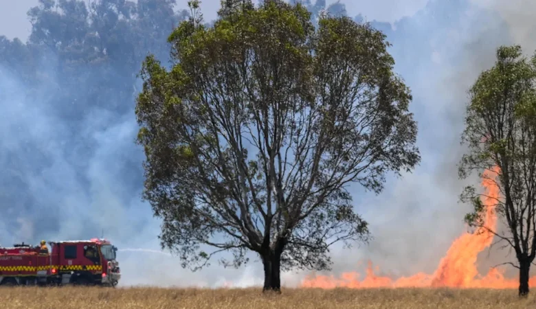
The grass fire burning north of Benalla.Justin McManus
An emergency warning was issued for Broken Creek, Goomalibee and Goorambat in the Hume region on Thursday afternoon, with residents urged to leave immediately as the more than 1400-hectares grass fire travels east.
Authorities are urging anyone in the warning area to evacuate south towards Benalla, where there is a relief centre at Benalla Town Hall.
A second grass fire is burning out of control near Charlton – a town about 100 kilometres north-west of Bendigo – and authorities have advised locals to stay near shelter and not return home.
The State Control Centre’s David Nugent urged people near the fires to remain vigilant and stay up to date with the latest information.
“For those farming communities where we know harvesting is important for you, please consider the postponing of your paddock work … these conditions really create a significant risk for the starting of fires,” he said.
A total fire ban has been declared for the Wimmera and Mallee regions for Friday and northern regions of Victoria have been designated as high risk for fires.
A severe heatwave warning has been issued for most of Victoria: across the northern country, north-east, east Gippsland, west and south Gippsland and north-central regions.
Authorities this week urged Victorians to remain vigilant in hot conditions to avoid causing bushfires, but Bureau of Meteorology forecaster Jonathan How said the calm conditions would aid firefighters if a blaze were to start.
“Thankfully, it’s not super windy, so even though it’s really hot, we’re not seeing those very gusty northern winds, which can usually drive elevated fire dangers,” said How. “Regardless, we still have extreme fire danger for the Wimmera and high for most other districts.
The temperature in Melbourne is forecast to drop to 20 degrees overnight, and then rise again to 33 degrees on Friday.
A cool change is then expected to sweep through the city on Friday evening, with the chance of small thunderstorms and rain.
Photo: Matt Golding
Bureau meteorologist Bri Macpherson said the hot temperatures and humidity would persist until the weekend, providing some settled weather for Christmas – which has a forecast high of 19 degrees.
“But really not much in the way of rainfall expected, just cooler than average but settled so not a bad for a roast,” Macpherson said.
The heat will rise again the following day as the Boxing Day Test kicks off at the MCG. The bureau has not yet released a forecast for New Year’s Eve.
How said the weather was quite erratic. “At the moment, across Melbourne and Victoria, we’re kind of see-sawing between hot and cool,” he said.
“This week’s a perfect example: we’ve got [high] temperatures today, but then Christmas Day is going to be quite cool. People need to bring their jackets out for Christmas lunch and Christmas evening, before it warms up again on Boxing Day.”
“We are probably still in that transition period between spring and summer. As we head into January, that’s when we would normally start to see things getting a little bit more stable.
But, if you live in Melbourne, you do know that things can change quite quickly.”
Related Article
As the state heats up, police are reminding the public that fire safety is a “personal responsibility”, warning that reckless behaviour can lead to catastrophic results.
“A fire started through reckless behaviour can have the same outcomes as a deliberately lit fire, including significant loss of life, serious injury, property damage and more,” police said in a statement on Thursday morning.
Arson and explosives squad detective inspector Chris Murray said it served as an important reminder to the community that “if you light it, you own it”.
“We won’t hesitate to hold those to account for starting a fire – whether it is recklessly or deliberately lit, the outcome is usually the same,” he said.
Start the day with a summary of the day’s most important and interesting stories, analysis and insights. Sign up for our Morning Edition newsletter.
Save
You have reached your maximum number of saved items.
Remove items from your saved list to add more.
Angus Delaney is a reporter at The Age. Email him at angus.delaney@theage.com.au or contact him securely on Signal at angusdelaney.31Connect via email.