Forecast data show the first signs of an unusually early warming of the polar stratosphere, indicating a potential weakening of the Northern Hemisphere polar vortex.
According to an analysis by Andrej Flis from Severe Weather Europe, the warming signal is developing over the upper stratosphere, around 10 mb (approximately 30 km/ 18.5 miles altitude), and could lead to a slower or disrupted vortex during the first half of winter 2025–26.
The polar vortex is a large cyclonic circulation of cold air centered near the poles at stratospheric levels. When strong and stable, it tends to keep Arctic air confined to high latitudes.
The stratospheric Polar Vortex looks like a large “cyclone” with a cold core near its low-pressure center. Image credit: Tomer Burg/Polar WX
When weakened or displaced by a stratospheric warming event, the circulation can falter, allowing cold polar air to move into mid-latitudes of North America, Europe, and Asia.
Model projections for late November and early December 2025 indicate an increasing temperature anomaly in the polar stratosphere.
This anomaly is expected to reduce wind speeds around the vortex, signaling a slowdown phase. The forecast shows a developing high-pressure anomaly over the polar region, pushing into the vortex core and displacing cold air southward.
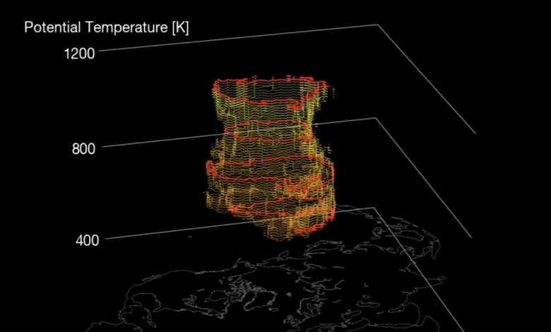
3D model view of the whole Polar Vortex. Image credit: SWE
In the troposphere, the forecast suggests a possible cold-air anomaly spreading from southern Canada into the northern and central United States during early December.
At the same time, a weakening of the jet stream pattern could enhance snowfall potential across parts of the Midwest and Great Lakes region.
For Europe, model data indicate a negative temperature anomaly over northern and central areas, including the United Kingdom, Scandinavia, and central Europe, while southern Europe remains largely unaffected. Early-season snow coverage may increase over northern Europe if the polar-air flow intensifies.
Image credit: Stratobserve
Such early-season stratospheric disturbances are uncommon. They can influence weather patterns for weeks to months, depending on the extent to which stratospheric signals propagate downward into the troposphere.
A weaker polar vortex typically favors increased meridional flow—allowing Arctic cold to reach mid-latitudes—and could lead to a more variable winter pattern across North America and Europe in the coming months.
Image credit: NOAA
References:
1 A significant Polar Vortex slowdown is forecast, bringing Cold Weather for Winter 2025/2026 – SWE – November 5, 2025