Scotland weather maps turn purple as the country braces for four day snowfall

Several areas of Scotland are expected to be hit with snow as the weather map turns purple for four days…
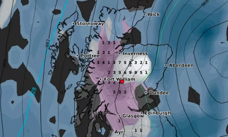
Scotland is expected to be hit with large snowfalls as the map turns purple (Image: WXCharts)
After a brief spell of milder autumn weather that saw many Scots swapping out heavy coats for lighter layers, winter looks set to make a rapid comeback next week. Forecasts suggest it’s time to dust off the hats, scarves and gloves once again, as Scotland braces for its first real taste of snow this season.
According to the latest WXCharts data, which uses MetDesk forecasting models, much of Scotland will face a distinctly wintry turn from Tuesday, November 18, as cold Arctic air pushes into much of the country.
Additionally, the maps indicate that temperatures will plunge midweek, allowing snow to fall across several regions, particularly in the Highlands and western areas.
Following a relatively calm and mild start to November, the arrival of colder air from the north is expected to trigger frosty mornings, freezing winds and the first widespread flurries of snow in the coming days.
WXCharts snow-depth and temperature charts show conditions will begin to shift from Tuesday (November 18), with the first landing of snow appearing in the north and northwest Highlands, gradually spreading southward through the week.
According to WXCharts, snow is expected to start in the Highlands (Image: WXCharts)
The Highlands are forecast to bear the brunt of the snow, as several different areas will find themselves blanketed in snow.
Fort William is projected to see the heaviest snow fall, up to 8-10 cm of snow depth possibly by Friday. While Inverness is expected to see 4-6 cm, mainly on higher grounds.
Portree are also expected to catch moderate snowfall as the weather develops. Its projected to get between 3-5 cm, mostly wet snow which will turn to sleet at lower levels.
WXCharts data shows that snowfall will start lightly midweek and intensify by Thursday, November 20, with snow-depth charts highlighting significant fall over the areas with higher elevation.
By Thursday, the cold front is expected to push further south, bringing the snow to parts of the Central Belt, including around Glasgow and Stirling, before the snow stops and temperatures reach around freezing.
The maps turn purple by Friday, November 21, showing that a large amount of snow will blanket around the country, which will affect much of the west and north of Scotland.
In Cairngorms, a whopping 10-15 cm is projected to fall, the heaviest expected to land mostly on Ben Nevis. An up to 6cm is expected across the Central Belt in, mainly in short-lived flurries but cold winds and icy conditions.
The snowfall will peak on Thursday, November 20(Image: WXCharts)
Currently, the Met Office does not anticipate snow, but has warned of conditions taking an “unsettled” turn within this timeframe.
Its long range forecast for the period November 14 until November 23 reads: “The start of this period is likely to be unsettled and mild for most, with slow-moving bands of rain which could be quite heavy and prolonged in some areas.
“With time, the more unsettled conditions should gradually clear to the south, allowing a colder and more showery northerly flow of sorts to become established. In this setup, showers may be wintry over high ground, and perhaps occasionally to low levels in the far north, with also a greater risk of overnight frost.
“However, the timing of this transition is rather uncertain, and it could remain milder and wetter into the beginning of the following week, especially in the south. A general downward trend in temperature is most likely through this period, to below average in many areas beyond mid-November.”


