We are getting into winter now, with predictions that our first proper Arctic blast may be on the way later this month brining low temperatures and night frosts
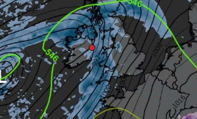
WX CHARTS
Ireland is in for some wintery weather, as temperatures drop and conditions remain wet and windy.
A “winter blast” may move in from next week, with temperatures dropping as low as between -2 and -4. This will be coupled with mist and showers.
Cathal Nolan from Ireland’s Weather Channel’s latest weather forecast has warned of hard overnight frosts and temperatures as low as -4 degrees. He added that Ireland will soon see its first “true Arctic blast” of the winter season.
He said: “It’s about to turn a lot colder next week with the first true Arctic blast of the new winter season ahead of us. Daytime temperatures through the first half at least of next week will struggle to reach about 5-7 degrees Celsius in places, with severe night frosts likely with temperatures of -3 or -4 possible in some areas.
“The weather during this period looks like being mostly settled, though the ECMWF is trying to generate an area of low pressure that could generate some persistent showery spells of, perhaps, wintry precipitation, especially over the higher ground of northern parts of the country.”
However, until this icy cold weather arrives, rain will be the most dominant feature: “In the meantime however flooding is our primary concern, both today, and certainly so on Friday as two periods of heavy rain will occur with southern and eastern parts most at risk of seeing the heaviest falls. In general, between these two episodes, and some smaller falls of rain tomorrow, up to 140mm is possible.
While January and February are the most likely months to get snow in this country, there is always a chance that it could arrive sooner. Weather forecasters WX Charts are predicting snowfall in Ireland may start as early as November 19th or 20th, with some small patches of it visible on their weather maps.
A view of Dublin’s Grafton Street as the ‘Beast from the East’ has hit Ireland with temperatures plunging to -3C tonight and snow showers along with a widespread frost and icy conditions.
On Wednesday, February 28, 2018, in Dublin, Ireland. (Photo by Artur Widak/NurPhoto via Getty Images)
Long range forecasts like this are always subject to change. You can follow the maps for yourself on the WX Charts site.
Met Eireann have a long range prediction for the same week, however, indicates that weather may be more settled: “There is a signal for a northerly air-flow to become established over Ireland during the week as a Blocking High Pressure develops in the mid-Atlantic.
The weather is likely to turn somewhat more settled with rainfall totals during the week forecast to be near or below normal. Mean air temperatures are likely to trend around or slightly below the climatological average.”
The national forecasters predictions for Dublin include plenty of rain but with some dry spells and light breezes.
Tuesday
Clear spells and isolated showers this evening and tonight. Some mist and fog patches will form overnight as winds fall light. Lowest temperatures of 5 to 8 degrees with light breezes.
Wednesday
Any mist or fog will clear during the morning with sunny spells developing. Cloud increasing during the afternoon with outbreaks of showery rain moving up from the south. Highest temperatures of 10 to 12 degrees in light to moderate northeast or variable breezes.
On Wednesday night, cloud and showery rain will move northwards over the country. The rain will persist in Ulster and parts of Connacht and north Leinster overnight but it will become drier further south. Lowest temperatures of 5 to 10 degrees with light to moderate, variable winds.
Thursday
Northern areas will stay mainly cloudy with rain and moderate northeasterly winds. Further to the south it will be drier and brighter with sunny spells and just well scattered showers, along with light and variable breezes. Highest temperatures will range between 7 and 13 degrees from north to south. Thursday night will become breezy as a moderate to fresh northeasterly wind develops. Cloud and patchy rain or drizzle will move up over the southern half of the country but it will be dry further north. Lowest temperatures ranging between 4 degrees in the north and 9 degrees in the south.
Join our Dublin Live breaking news service on WhatsApp. Click this link to receive your daily dose of Dublin Live content.
We also treat our community members to special offers, promotions, and adverts from us and our partners. If you don’t like our community, you can check out any time you like. If you’re curious, you can read our Privacy Notice .
For all the latest news from Dublin and surrounding areas visit our homepage .