(TNS) — When Andria McClellanconcluded eight years on Norfolk City Council, she didn’t let the concerns of her constituents disappear.
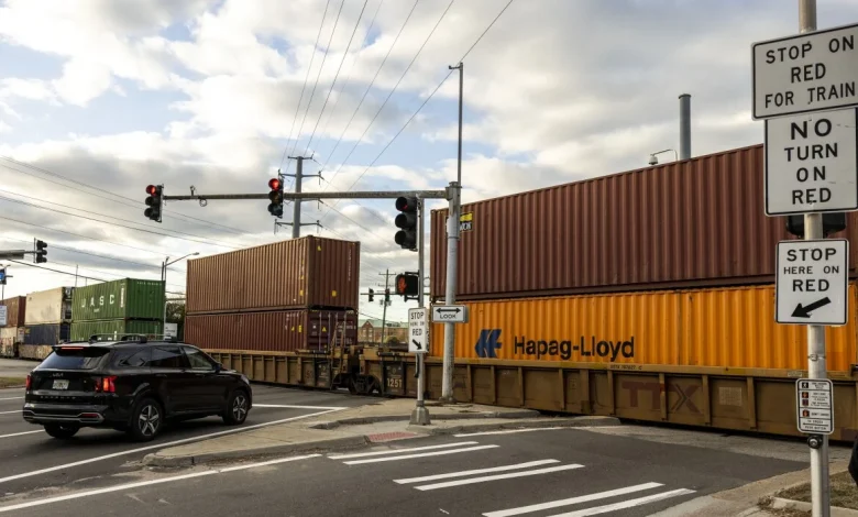
Throughout the years, she’s heard plenty of complaints from residents about the backups caused by trains crossing roadways. The Norfolk resident has experienced them herself.
And now in her next chapter, she’s created a digital app that alerts drivers when railroad crossings are blocked.
She founded her company, Oculus Rail, in early 2024. After a nationwide search for a technology partner, McClellan discovered exactly what she needed in Hampton Roads: Port Solution Integrators. The Portsmouth-based company created solar-powered wireless sensors and the algorithm and data integration for the app.
The pilot for Oculus Rail launched in October, and within a couple of weeks, it expanded nationwide. More than 2,000 people have already downloaded the free app, available at the App Store and Google Play, McClellan said.
Michael Millard-Lowe, owner of three Norfolk businesses: Hunt and Gather, The Gilded Shoestring and Michael Millard-Lowe Antiques, uses the app daily. He referred to blocked crossings as his biggest pet peeve.
“You see the traffic backups on 21st Street and all the streets around there,” Millard-Lowe said. “Everybody who lives around there has their favorite conjugated verb: I was stuck, I am stuck, and I will be stuck.”
Forty solar-powered sensors at railroad crossings in Norfolk, Portsmouth, Chesapeake and Suffolk enable the app to alert users in real time when trains are blocking roadways. Those cities, according to McClellan, have the largest concentration of rail crossings in the commonwealth.
“It really showcases the power of the technology,” she said.
Through the use of artificial intelligence-backed technology, the sensors can detect the length of time a train has been crossing a roadway and the average time it takes. Indicators on the app’s map turn from green to orange to indicate the crossing is blocked and back to green once it is cleared.
McClellan’s goal is for the app to be the “Waze of railroad crossings,” and said talks are underway with both Google Maps and Waze to see if the data can be integrated.
Oculus Rail owns, installs and maintains the sensors and provides the data to the city. For every crossing the city subscribes to, the data is provided to motorists via the app.
“We work with municipalities to determine which crossings they want provided in the app for an annual low-cost data subscription,” McClellan said.
Subscription pricing, generally $2,500 to $5,000 per crossing, is based on the number of crossings, plus a one-time installation fee.
Pavithra Parthasarathi, deputy executive director for the Hampton Roads Transportation Planning Organization, said in an email that they are working on a review of the top 25 most troublesome crossings in the region.
“Based on staff experience, the Oculus Rail app provides the public with the option to adjust their route or change the time when they travel based on rail crossing blockage information that is not available anywhere else,” Parthasarathi said.
McClellan’s husband, Mike, is a senior vice president and chief strategy officer for Norfolk Southern. She said he has been an adviser since early on.
Oculus Rail is a small enterprise with big ideas, McClellan said. The business is interested in expanding to bridges, road flooding and other issues that affect motorists.
“I have been a public servant for the last decade or so and I feel like this is an extension of my career,” she said. “I’m just trying to solve a problem and make the quality of life better for the residents of Hampton Roads and, hopefully, the United States.”
©2025 The Virginian-Pilot, Distributed by Tribune Content Agency, LLC.