Polar vortex could bring a huge drop in temperatures right after Thanksgiving. Here’s what to know.
“The variability across such events is high, but if you are in the ‘sweet’ spot, (which is) dependent on your perspective, a region can experience a prolonged period of severe winter weather, such as multiple snowfall events and/or repeated cold air outbreaks,” said Judah Cohen, a research scientist at MIT and climatologist. “…This particular event is looking to be a polar vortex displacement, which based on past events is more prolific at delivering cold than blockbuster snowstorms, but certainly I wouldn’t rule it out.”
What makes this sudden warming so rare is the timing. Sudden Stratospheric Warming events do occasionally happen, but typically in the depths of winter and toward the transition into spring. This is early for this type of event, signaling an earlier arrival of freezing winter-like conditions.
It also means that the polar vortex is weakening much earlier than usual, which would make it the most unstable vortex the planet has seen in November since the 1960s. Right now, I’m more concerned with how long it is forecast to remain weak versus how weak it gets. The reliable forecast models are showing colder-than-average temperatures to close out the month, with the intense cold peaking during the first week or two of December.
The northern tier of the country, including New England, may see colder-than-average temperatures late November into mid-December.Boston Globe
How does Sudden Stratospheric Warming impact the polar vortex?
Let’s break it down. Sudden Stratospheric Warming (SSW) is a warming of the upper atmosphere, called the stratosphere. This is also where the polar vortex lives, miles above the surface — a tight band of wind that holds frigid air at the Earth’s poles. Our weather occurs in the troposphere, the layer of the atmosphere just below and closest to the surface.
The sudden warming of the stratosphere is a subtle but impactful event because it’s the very first key to weakening and unlocking the polar vortex, which can send pockets of frigid cold air south into the U.S.
This is how it works: If strong enough, this disruption to the polar vortex can force waves of relatively warmer air high in the atmosphere to slam against the polar vortex winds. Just like waves breaking along the beach, these “air waves” will break or crash across the vortex, forcing vortex winds to slow or reverse.
This change in wind speed and intensity results in the wobbling, stretching, or even splitting of the vortex, causing the release shots of exceptionally cold air southward, sinking to the surface like “dripping paint,” according to Cohen, “as the tenticles, or influence from the sudden warming way up in the stratosphere, reach the surface multiple times.”
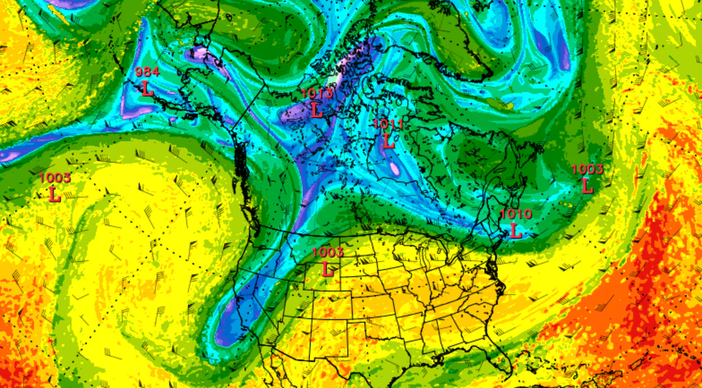
A disrupted polar vortex will send pockets of Arctic air south into the United States.Boston Globe
This far out, the exact weather pattern remains to be seen as to who will feel the brunt of these potential Arctic blasts. But it does look like everywhere from the Northern Rockies through the Midwest and into New England will be hit by an intense cold snap after Thanksgiving. These upper-level weather events take some time to reach the surface, so I’m thinking we’ll see the bulk of the cold arrive in the first week of December.
With an unstable polar vortex, combined with other cold signals in the natural oscillations that dictate climate patterns, such as La Niña and the Madden-Julian Oscillation (MJO), we can expect more volatility in the weather, increasing the chances for cold spells and early-season winter snow and ice storms.
We’re in for a long cold stretch
The forecast temperature in the stratosphere is forecast to increase over the next couple of weeks (marked in green), causing parts of the polar vortex to spill southward.NOAA
The European model does a great job of forecasting the average wind speed of the polar vortex. The concern here isn’t so much the stopping or reversal of wind direction (average forecast represented by the thick blue line). But take a look at how long the winds will be below average (thick red line). That means that colder-than-normal air may be slinging into New England for a long stretch. Thankfully, this is happening in late November into December, versus January, or it would be dangerously cold for many Americans.
Wind speeds that hold the polar vortex tight around the poles are forecast to slow dramatically by the end of November, perhaps even reversing slightly.NOAA
Cold air and snow go hand-in-hand, so perhaps we’re going to be forecasting snowstorms early and often this winter.
Sign up here for our daily Globe Weather Forecast that will arrive straight into your inbox bright and early each weekday morning.
Ken Mahan can be reached at ken.mahan@globe.com. Follow him on Instagram @kenmahantheweatherman.