The Northern Territory’s reprieve from the first cyclone of the season is set to be brief, with Fina set to return to category 2 status, and possibly even category 3, today.
At 9.30pm (11pm AEDT), peak gusts were about 100km/h as the storm tracked south about 360 kilometres north-east of Darwin and 135 kilometres north-north-east of Minjilang, on Croker Island.
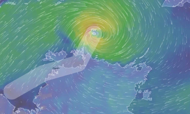
Tropical Cyclone Fina has pivoted towards the Northern Territory and is expected to pick up momentum as it approaches in the coming hours. (Ventusky)
The Bureau of Meteorology expected it to return to category 2 strength some time today on its approach towards the Cobourg Peninsula and Tiwi Islands.
Fina was then forecast to head through the Van Diemen Gulf on Saturday and become a severe cyclone on Sunday afternoon in the southern Timor Sea.
But forecasters warned it could also hit category 3 as early as today or early tomorrow.
Bureau spokesperson Jude Scott said the cyclone would continue to move in a south-westerly direction over the next couple of days.
Widespread daily rainfall totals of between 50 millimetres and 200 millimetres were forecast for areas in the warning and watch areas.
“This could be 300 millimetres of rain in the areas closest to the centre of the system,” Scott said yesterday.
Bureau of Meteorology community engagement manager Jude Scott. (Nine)
“An initial flood watch has been issued for the north-west coastal rivers as creeks and rivers will rise in response to the forecast rainfall.
“Darwin is now in the cyclone watch area and that’s because there is a risk of gales on Saturday, probably from later in the morning into the afternoon.”
She said the impact on Darwin would depend on the cyclone’s eventual path.
“If the track hugs the Tiwi Island coast, then the impacts will be less on Darwin.
“If the track moves closer to the mainland north Australian coast then Darwin is likely to see the impacts of the cyclone during Saturday.”
The warning zone covers Milikapiti to Maningrida, including the Cobourg Peninsula, Minjilang and Warruwi.
Forecasters warned of wind gusts up to 120km/h over the Cobourg Peninsula between Cape Don and Warruwi last night, with possible destructive winds up to 155km/h today in the same area as the system nears the coast.