Shona McGarty bursts into tears over ‘love interest’ Aitch’s shock exit before I’m A Celebrity finale
I’M A Celebrity’s Shona McGarty sobbed over losing her ‘love interest’ Aitch a night before the show’s finale.
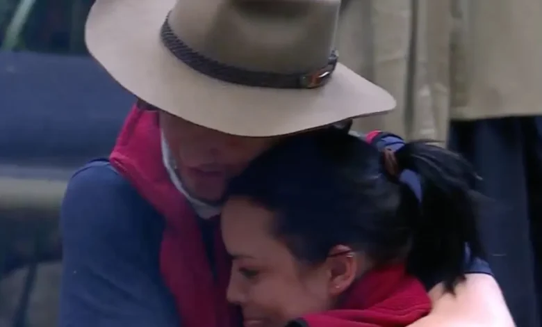
The EastEnders star burst into tears in the arms of her fellow finalists Angry Ginge and Tom Read Wilson.
Sign up for the newsletter
Thank you!
Shona McGarty broke down in tears in Aitch’s arms
Shona was comforted by Ginge and Tom
Ginge told her “come here” as he pulled her in to cry on his chest before being joined by an emotional Tom moments after Aitch left camp.
Shona looked inconsolable as Aitch narrowly missed out on a spot in the final – with Ginge reassuring her: “You’ll see him in a day.”
She and Aitch had raised hopes of a jungle love story earlier in the series after the rapper said he had a “soft spot” for the former EastEnders actress.
In one episode, Aitch, 25, was seen wrapping his legs around Shona, 34, during a play fight, and they also cuddled up while watching a trial.
AITCH TELLS ALL
I’m a Celeb’s Aitch reveals he almost QUIT after facing very ‘low moments’
bridal era?
I’m A Celeb’s Lisa Riley hints she’s secretly married after jungle elimination
But he was stunned to hear about the speculation after he exited camp in fourth place in a shock elimination.
He said he bonded with Shona over their love for music – with Shona seeking to carve out a new career as a singer after releasing her debut single – but denied any potential romance.
Mancunian Aitch, whose real name is Harrison Armstrong, told The Sun: “I’ve just heard it five minutes ago!
“No, Shona’s just a cool person. I feel like me and Shona are just cut from the same cloth in a way. We just have the same sense of humour.
Most read in I’m A Celebrity 2025
“Obviously I’ve not watched the show, so I don’t know what’s been put out there in any way – but it was nothing like that.
“I just think we had a bond over a bit of a music thing – me knowing that she’s trying to come out of the jungle and pursue this music career, me having a music career.
“It was just more like there’s only really me and Martin (Kemp) she can speak to about certain things.
“I think just because of my age… no one’s going to say that she had a romance with Martin, because Martin’s married.
“So unfortunately I’m the next option.”
Aitch had predicted his elimination the night before