A cascade of severe thunderstorms are rolling in across NSW, as millions of Aussies experience large hailstones and damaging winds.
Severe thunderstorms, damaging winds and large hailstones hit Blackheath, Oakdale, Dapto, Lake Avon, the Rylstone/Kandos district and the Bathurst district.
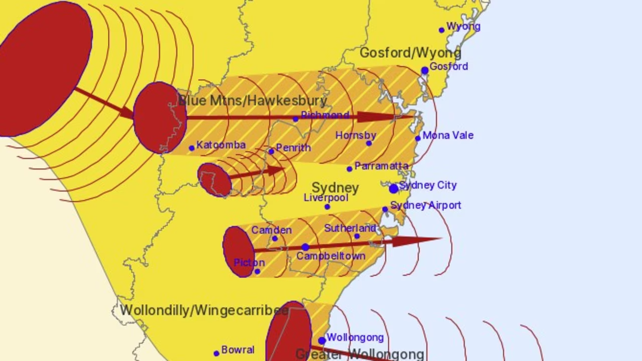
These thunderstorms are moving towards the east to southeast.
They are forecast to affect Wollongong, Katoomba, Richmond, Camden, Campbelltown, Penrith and Picton by 12.40pm and Hornsby, Sutherland, Sydney Airport and Mona Vale by 1.10pm.
The severe weather warning covers a coastline spanning roughly 250km from the outskirts of Nowra to Wyong on the NSW Central Coast.
Wild footage has captured the moment one of the storm cells began to roll across the suburb of Bungarribee in western Sydney.
Amid the downpour, one neighbour shouts: “Oh no, hail!”
Trees flail in the wind and bins are knocked over and carried away as the residents duck for cover.
In the bureau’s latest update, issued at 1.57pm, it warns a cold front is moving through NSW and combining with an upper-level trough and an unstable air mass to produce severe thunderstorms over Wednesday afternoon and evening.
“Very dangerous thunderstorms are likely to produce damaging, locally destructive winds, large hailstones and heavy rainfall that may lead to flash flooding over the next several hours in parts of the Hunter district,” the warning states.
Severe thunderstorms are likely to produce damaging winds and large hailstones over the next several hours in the Hunter and parts of the Mid North Coast, Metropolitan, Central Tablelands, North West Slopes and Plains, Central West Slopes and Plains and Upper Western districts.
Locations that may be affected include Newcastle, Gosford, Sydney, Tamworth, Bourke and Scone.
Meteorologist Miriam Bradbury said the damaging wind warning covered the ACT and the winds were strong enough to bring down trees and even powerlines.
“We can see they’re wrapping around a couple of low-pressure troughs that are moving across the southeast,” she said.
Ms Bradbury said one low pressure trough was already moving across Victoria, with showers and storms “streaming” ahead and impacting the southern state.
The range of temperatures across NSW were driving extreme fire dangers contained in the bureau’s previous warning.
Motorway closed after tree falls
The M7 Motorway near Eastern Rd in Rooty Hill has been closed due to a fallen tree, a warning from Live Traffic NSW states.
Heavy traffic conditions are already erupting and motorists are being urged to use an alternative route.
Fallen overhead wires near Carlingford have led to the L4 Westmead and Carlingford Line light rail services being suspended.
Services are still running between Rosehill and Westmead, Transport NSW said in a statement.
“Train passengers travelling on the T1 North Shore and Western Line, T5 Cumberland Line and Blue Mountains Line are advised to allow plenty of extra travel time due to severe weather causing power supply issues at various locations,” the statement continues.
“Trains around the Richmond, Penrith and Blacktown areas may stop on platforms or between stations for longer than normal, and stops may change at short notice.”
Transport NSW has urged passengers to consider delaying their trip or make alternative arrangements for travel.
Strong winds have already prompted emergency responses, with paramedics attending a home in St Marys after a tree fell.
NewsWire understands a mother and her child were inside the home at the time.
Patients were being assessed for treatment, NSW Ambulance said.
The NSW State Emergency Service (SES) has also issued warnings amid the slew of dangerous weather alerts.
Residents in Orange, Bathurst and surrounds are being advised to stay indoors and keep away from damaging winds.
“Severe thunderstorms and damaging winds are bringing down trees causing property damage and affecting roads in the area.
“You should monitor the situation as it is constantly changing.”
Wind gusts of up to 110km/h have already been recorded at Orange at 11.52am.
It follows renewed warnings of “catastrophic” fire danger and schools being shut.
The mercury is expected to soar in the state’s capital on Wednesday, with temperatures tipped to peak at 36C in Sydney.
Damaging winds in excess of 90km/h have started to develop across the state’s southeast and are expected to stick around through much of Wednesday before settling in the evening.
Locations that may be affected include Wollongong, Nowra, Canberra, Goulburn, Bowral and Katoomba.
The Bureau of Meteorology is warning that the strong and gusty winds combined with extremely hot and dry weather could create “very dangerous” fire conditions.
“We’re seeing a number of districts experiencing extreme or possibly even catastrophic fire dangers,” senior meteorologist Miriam Bradbury said.
Due to the oppressive heat and fire danger warnings, the Department of Education has shuttered 25 public schools across the state.
The affected schools include: Ariah Park Central School, Barellan Central School, Bedgerabong Public School, Binya Public School, Bogan Gate Public School, Boree Creek Public School, Caragabal Public School, Ganmain Public School, Greenethorpe Public School, Lake Wyangan Public School, Lowesdale Public School, Marrar Public School, Matong Public School, Naradhan Public School, Narrandera East Infants School, Narrandera High School, Pleasant Hills Public School, Tallimba Public School, Tharbogang Public School, The Rock Central School, Ungarie Central School, Wamoon Public School, Weethalle Public School, Whitton-Murrami Public School and Yerong Creek Public School.
All independent schools in NSW remain open and operational.
Aside from the wind and suffocating heat, thunderstorms will also pepper northern and eastern NSW.
“For NSW, we’re more likely to see the damaging wind gusts and the large hail,” Ms Bradbury said.
“There is even a small chance we could see destructive wind gust and giant-sized hail, which is greater than 5cm in diameter across parts of the Northern Rivers.”
The risk of severe damage is most likely in the afternoon and evening.
“For communities which have already seen a few days of very strong severe storms, this is yet another day of very unsettled weather,” she said.
More storm danger for battered Queensland
After wild storms ripped through parts of Queensland on Monday and Tuesday, residents can expect the unsettled conditions to continue once again.
About 38,000 people in the state remain without power after the devastating storms.
As of Wednesday morning, about 24,000 homes and businesses remain without power in Moreton Bay and another 7000 in Noosa.
An Energex spokesperson confirmed 4000 on the Sunshine Coast were still without power, 700 in Logan and 600 in Somerset.
They said power had already been restored for about 120,000 homes and businesses, and that most others should be reconnected by 8pm on Wednesday.
“However some areas of severe damage around Bribie Island and the Sunshine Coast are likely to be without power into Thursday,” a statement read.
“Energex asks for residents to take extreme care when cleaning up storm debris, particularly fallen trees and vegetation, as fallen powerlines may be hidden underneath debris and could well be live.”
Storms are likely to continue for Queensland on Wednesday, affecting almost the entire coast.
“Storms are possible pretty much anywhere in Queensland, except for the far northern tip of the Cape York Peninsula,” Ms Bradbury said.
“Severe storms, however, are possible right along the coast, so that extends from the southern parts of the Cape York Peninsula all the way through the eastern districts of Queensland and into the southeast, then pushes down across northeast.”
Residents in the northern and central regions have been warned of heavy rainfall, damaging winds and possibly large hail.
Storms, wind and rain rip through SA, Victoria
Thunderstorms won’t be isolated to Queensland and NSW, as a cold front passes over the country’s southeast, bringing unsettled and wild conditions.
The bureau forecasts thunderstorms to pass over South Australia and Victoria, bringing heavy rain, blistering winds and lightning.
Residents will feel the brunt of the storms in southeastern SA as well as Adelaide before they move into Victoria and settle in Melbourne.
“These areas could see thunderstorms, pretty gusty thunderstorms moving through with the front today,” Ms Bradbury said.
“(The storms) could produce those locally damaging wind gusts.”
In Brisbane, it will be a warm and wet day, with a high chance of showers and a possible thunderstorm with plenty of hail and damaging winds, reaching a maximum of 35C.
Sydney will be hot and mostly sunny, though there is a chance of a thunderstorm and a shower in the early afternoon, reaching a top of 36C.
Skies will be partly cloudy in Canberra, with “very windy” conditions, a possible thunderstorm in the afternoon and a forecast maximum of 27C.
Melbourne will be gloomy and cloudy on Wednesday, with a very high chance of showers and a thunderstorm in the morning as the mercury tips to 21C.
It will also be cloudy and wet in Hobart, with a maximum temperature of 19C.
Similar conditions can be expected in Adelaide, with cloudy skies, a high chance of showers and a top of 21C.
Sunny skies will dominate Perth on Wednesday with a slight chance of a shower in the morning and temperatures forecast to hit 24C.
Darwin residents can expect cloudy skies and a medium chance of showers, with a possible thunderstorm and a top of 33C.
Read related topics:Sydney