Snow is forecast in the UK again and weather maps highlight how severe the next Arctic weather blast could be, particularly across parts of the Midlands, and the Northwest of England
05:00, 26 Nov 2025
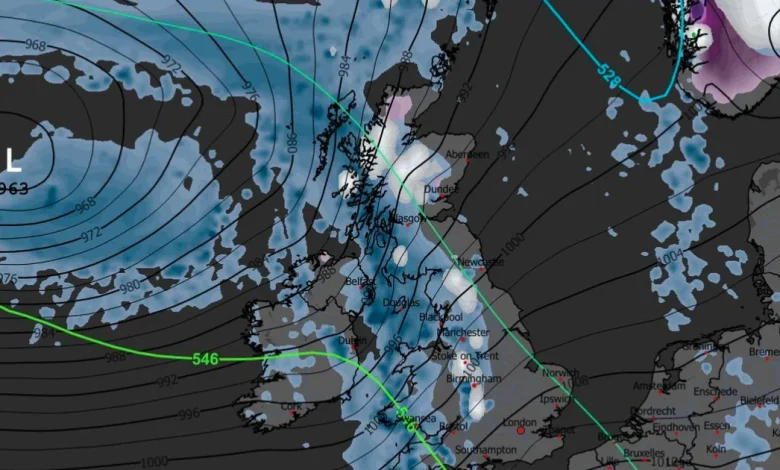
Weather maps show snow is forecast in the next couple of weeks
This striking weather map shows the exact date forecasters anticipate the next major Arctic weather blast.
Up to seven inches of snow is expected when the latest band of freezing low pressure drives across the UK from the northwest and works its way slowly south. Temperatures have increased since last week’s cold snap, which snow fall as far south as London, but the mercury is anticipated to plunge in early December.
This will lead to the next period of snowfall, which forecasters with Metdesk say is likely on Saturday December 6 and may persist for a couple of days thereafter. Weather maps issued by the team show white hues as far south as the Cotswolds on the morning of December 6 with snow believed to be widespread for some time.
The thickest white splodges on the WX Chart are across the Scotland Highlands, Cumbria and Staffordshire. We reported yesterday seven inches is forecast in such places and light dustings are likely elsewhere later that day, including most of Wales and the Northwest of England.
READ MORE: UK weather: Met Office gives early indication to chances of Christmas snowREAD MORE: Nine-year-old battles arctic weather conditions to reach Everest Base CampVillages across the North York Moors saw significant snowfall last week(Image: PA)
But it is unlikely this pattern will continue throughout the month and lead to a white Christmas, the Mirror reported. This is despite statistics showing that more than half of all Christmas Days in the UK have seen snow falling somewhere.
Temperatures will, instead, rise in the week after the next Arctic storm. They plunged below freezing last week across the country but Monday saw a high of 11.7C, recorded near Preston, Lancashire.
But in the days before December 6 — the Arctic storm — conditions will be cold and wet for most of the UK, it is understood. Forecasters at Netweather believe it will be particularly rainy, until the air temperature gets cold enough for snow.
Nick Finnis, writing on the meteorological service’s blog, said: “Highest rainfall totals across the west next week, where we could see well in excess of 100mm fall, also could be quite wet across the far south, as secondary lows run across here. So we may start to see an increase in flooding issues in the west and perhaps far south. Spring tides end of next week / following weekend could bring a risk of coastal flooding too should there be strong winds.”
And the BBC Weather forecast for the period of December 1 to December 7 reads: “A weakening front or two could bring a little rain farther southwards and eastwards, so it’s unlikely to be completely dry. The risk to the forecast is that high pressure will position itself differently – more strongly over Scandinavia, for example – which would mean chances of colder flows developing.”