Lake-effect snow lingers into Friday with dangerous travel in parts of western, central, and northern New York; brief break Saturday before another system arrives Sunday
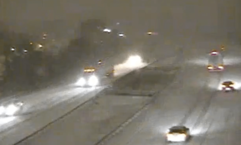
Heavy lake-effect snow that disrupted Thanksgiving travel across large portions of western and central New York is still ongoing early this morning, and the National Weather Service expects difficult conditions to continue through tonight. The most intense bands remain focused east and southeast of Lakes Erie and Ontario, but additional disruptions are possible across the broader region thanks to continued gusty winds, blowing snow, and narrow bands that shift through the day.
A short-lived lull arrives Saturday. After that, another round of light accumulating snow — and eventually a rain/snow mix — moves in Saturday night into Sunday, adding to travel complications for the second half of the holiday weekend.
Here’s the latest on what the National Weather Service says is coming for those traveling across Upstate New York with a region-by-region breakdown.
Through tonight: Lake-effect snow continues, with the heaviest totals southeast of both lakes
Cold, moist northwest flow across the Great Lakes is still fueling localized but intense lake-effect snow bands. Snowfall rates of 1–2 inches per hour remain possible in the strongest parts of these bands, with several inches of new accumulation likely through tonight.
Lake Erie: Southern Erie, Wyoming, Chautauqua, Cattaraugus, Allegany
- Snow remains primarily south of Buffalo into the western Southern Tier.
- Higher terrain in the Boston Hills, Chautauqua Ridge, and northern Cattaraugus County continues to see the most persistent snow.
- Additional 10–20 inches expected through tonight in the most persistent bands.
- Wind gusts 30–35 mph will cause continued blowing and drifting.
- Snow showers taper Friday night and end early Saturday.
The Niagara Frontier (Buffalo north) only sees occasional snow showers after a brief burst early this morning.
Lake Ontario: Wayne, Northern Cayuga, Oswego, Oneida, Madison
The most intense band off Lake Ontario has settled southeast of the lake and is expected to drift very little today.
- Wayne and northern Cayuga: 12–22 inches total expected by Saturday morning, greatest in the northeast portions of both counties.
- Oswego County: 8–18 inches, higher on the Tug Hill and far southern parts of the county.
- Oneida, Onondaga, Madison: 7–16 inches through early Saturday.
- Snowfall rates: up to 2 inches per hour, with thunder possible near the lakeshore.
- Conditions along I-81, Route 49, Route 3, Route 104, and the Thruway corridor east of Rochester remain hazardous.
Southern Tier & Central New York
Lighter but still disruptive snow continues:
- Steuben: 4–8 inches total, with highest amounts in western areas.
- Cortland, Chenango, Otsego, Southern Cayuga: 2–6 inches, primarily from drifting bands as they shift south.
- Northern Oneida remains under the most persistent band until early Saturday.
Visibility will change rapidly between whiteout conditions and clearer skies just miles apart.
Saturday: Snow winds down, brief period of quieter weather
By Saturday morning, the lake-effect engine finally shuts down as a ridge of high pressure moves overhead. Expect:
- Lingering snow showers early, especially southeast of the lakes.
- Gradual clearing through the afternoon.
- Highs in the low to mid 30s.
- Winds easing significantly.
Saturday will be the calmest travel day of the holiday weekend.
Saturday night–Sunday: New system brings light snow, then rain/snow mix
Another low-pressure system approaches late Saturday night, moving across the central Great Lakes on Sunday. Impacts will be more widespread, though less intense than the lake-effect event.
What to expect:
- Snow develops late Saturday night into Sunday morning.
- Widespread 1–3 inches, with 3–5 inches possible on the Tug Hill.
- Temperatures rise into the upper 30s and low 40s Sunday afternoon, changing snow to rain in lower elevations.
- It stays windy, with wind chills in the 20s.
- A quick cold front Sunday evening flips any rain back to snow overnight into Monday.
This system won’t produce crippling snow, but it will cause slick travel Sunday morning and evening.
Early next week: Another coastal system possible
Monday brings a brief quiet stretch before attention shifts to a potential coastal storm Tuesday. Forecast confidence is low:
- GFS track: closer to the coast, bringing widespread light snow inland.
- ECMWF/CMC: farther offshore and drier.
Either way, temperatures will favor snow for most of central and western New York if precipitation reaches inland.
Behind that system, colder air returns midweek with another short burst of lake-effect snow possible.
Active weather alerts through Saturday morning
Lake Effect Snow Warnings
- Until 1 AM Saturday: Jefferson, Lewis, Wyoming, Chautauqua, Cattaraugus, Southern Erie, Allegany
- Until 7 AM Saturday: Wayne, Northern Cayuga, Oswego, Northern Oneida, Southern Oneida, Onondaga, Madison, Southern Herkimer, Northern Herkimer, Hamilton
Winter Weather Advisories
- Until 7 AM Saturday: Southern Cayuga, Cortland, Chenango, Otsego
- Until 1 AM Saturday: Steuben, Warren (PA), McKean (PA), Potter (PA), Tioga (PA), Northern Erie (PA)
Bottom line for the rest of the weekend
- Friday: High-impact snow continues in multiple counties. Expect whiteouts, drifting, and very difficult travel.
- Saturday: Best travel day of the weekend—cold, but quiet.
- Sunday: Widespread light snow changes to rain; roads will be slick in the morning and again Sunday night.
- Early next week: More light snow possible with a coastal system.
Get the latest headlines delivered to your inbox each morning. Sign up for our Morning Edition to start your day. FL1 on the Go! Download the free FingerLakes1.com App for iOS (iPhone, iPad).
FingerLakes1.com is the region’s leading all-digital news publication. The company was founded in 1998 and has been keeping residents informed for more than two decades. Have a lead? Send it to [email protected].