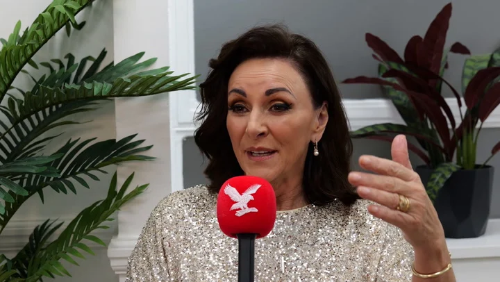
Tricks with showers on the way as kiddos grab those treats tonight

Halloween to have many tricks along with treats as Mother Nature hands out light rain chances, possible flurries at times, and cooler temperatures. Next week will bring in the treats (a little late but better late than never) with a pleasant warm up on the way.
Today will be on the cloudy side with some morning sprinkles and/or flurries possible around the area with temperatures hovering in the low to upper-30s around the area. As the day goes on, cloudy skies will continue to blanket the area as temperatures rise into the low to mid-40s by the afternoon hours with winds hovering between 5 and 15 mph. Showers will be widely scattered throughout the day with most of the showers being more of a drizzle to light rain around the area.
Trick-or-Treating hours will be on the crisp side with cloudy skies, light winds to a light breeze and spotty rain chances at times. Rain chances will range from a sprinkle or a drizzle to a light steady rainfall at times, though rain totals will remain light with up to a tenth of an inch or less across the area. This means that Trick-or-Treating this evening could have some rain chances mixed in. Temperatures through the evening will hover more in the upper-30s as kids go around collecting as many treats as they can.
Those spotty rain chances could end up becoming mixed with flurries overnight as temperatures drop back into the low to mid-30s by tomorrow morning.
Tomorrow will remain mostly cloudy with a few lingering sprinkles and/or flurries in the morning hours before those precipitation chances wrap up by the late morning and early afternoon hours. From there, we will see clouds gradually break apart leading to an increase in sunshine as the day goes on. Temperatures will top out in the low to mid-30s with winds reaching up to 10 mph. Saturday night will become mostly clear as temperatures drop into the low-30s by Sunday morning.
Sunday will then be partly cloudy to mostly sunny. Temperatures will warm up into the low to mid-50s by the afternoon hours with a breeze returning to the area. Winds are projected to hover between 15 and 20 mph with gusts up to 30 mph at times possible. Sunday night will be mostly clear as temperatures drop into the low-40s by Monday morning.
Next week is going to be on the more pleasant side with unseasonably warm temperatures across the area for most of the week. We are looking at mostly sunny skies for Monday, Tuesday and Wednesday. Temperatures for those three days will hover in the mid to upper-50s with winds averaging between 10 and 15 mph, gusts up to 25 mph at times possible. Overnight temperatures will likely drop into the mid-30s and low-40s by the following mornings.
Thursday through Sunday of next week and weekend will have a gradual cool down with the help of a cold front moving through on Friday. Skies will become partly cloudy to mostly cloudy throughout Thursday and then remain mostly cloudy throughout Friday with scattered showers moving in Thursday night. Temperatures will likely hover in the mid-50s for both Thursday and Friday with winds up to 20 mph, gusts up to 25 mph at times possible. Showers are anticipated to continue through the majority of Friday as of the current forecast. Temperatures will drop into the low to mid-40s by Friday morning and the upper-30s by Saturday morning.
Saturday and Sunday will continue with gradual cooling as skies teeter between partly cloudy and mostly cloudy. Temperatures will hover in the low-50s on Saturday and the upper-40s by Sunday afternoon. Winds will remain slightly breezy up to 15 mph, gusts up to 20 mph at times possible. Overnight temperatures are projected to drop into the mid-30s by Sunday morning and the mid-30s by Monday morning.
Click here to download the KEYC News Now app or our KEYC First Alert weather app.
Copyright 2025 KEYC. All rights reserved.


