Hail, thunder and lightning has hit south eastern Queenslandcutting power to hundreds.
Authorities are warning residents in northern NSW, the Gold Coast, Brisbane and the Sunshine Coast to stay inside tonight, as the ‘super cell’ thunderstorms move across the area.
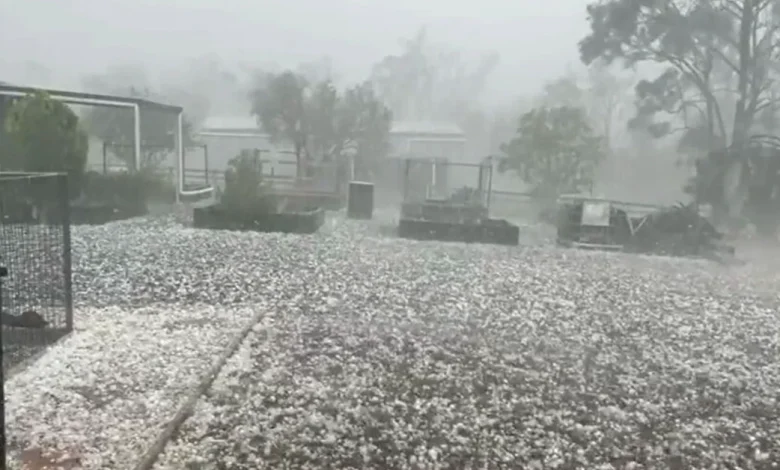
The storm struck Queensland’s Southern and Darling Down region around lunchtime, bringing hailstones as large as nine centimetres.
The storm struck Queensland’s Southern and Darling Down region around lunchtime, bringing hailstones as large as nine centimetres. (Supplied)
Five to eight centimetre hail fell across Toowoomba, Gatton, the Sunshine Coast, the Lockyer Valley and Brisbane as heavy rain continued to drench the region.
Lightning and dark clouds rolled in over Brisbane about 3pm, where the power was cut to almost 700 residents in Bowen Hills.
There are even warnings of tornadoes.
“When it comes to the wind, there is even an outside chance that we could see a tornado or two touch down with the most intense, most severe thunderstorm cells later on today,” BoM meteorologist Angus Hines said.
Severe thunderstorm warnings remain in place, with the Bureau cautioning the possibility of heavy rainfall that could lead to flash flooding, possibly giant hailstones and destructive winds across northern NSW and much of Queensland.
The worst of the storm is expected to hit Surfers Paradise, Gold Coast, the Brisbane metro area, the Sunshine Coast, Maleny and Noosa Heads.
Hailstorms have blasted multiple suburbs across Queensland. (Nine)
The Burnett region, Kingaroy and Gympie, as well as Biloela and Toowoomba are also in the firing line, Bureau of Meteorology meteorologist Angus Hines said.
“When it comes to the wind, there is even an outside chance that we could see a tornado or two touch down with the most intense, most severe thunderstorm cells later on today,”Hines said.
Residents in the NSW Northern Tablelands and across the North West Slopes and Plains, including Tamworth and Moree are also expected to be hit by the storms.
Coastal areas such as Port Macquarie, Coffs Harbour, Grafton, Ballina, Lismore and Byron Bay are also in the firing line.
Residents have been advised to pack away or secure outdoor furniture, toys and trampolines, park cars away from trees, close doors and windows.
The Bureau urged locals across northern NSW and south eastern Queensland to remain inside a “strong building” until the storm passes and advised against driving.
However, authorities have urged locals to keep up to date with the Bureau of Meteorology weather warnings due to how quickly the weather can turn.
Rainy conditions and storms in some areas may continue tomorrow, but overall conditions are expected to improve.
Inland areas from Brisbane to Bundaberg may still see severe thunderstorms tomorrow.