PORTLAND, Ore. (KATU) — The National Weather Service in Portland has issued a “Special Weather Statement” addressing the small risk of seeing severe thunderstorms and the chance of a waterspout, funnel cloud, or tornado.
WEATHER | Latest Storm Tracker 2 Forecast
“Stronger showers and thunderstorms will have the potential to produce locally damaging wind gusts up to 60 mph and/or a funnel cloud or brief tornado,” NWS Portland said in the statement.
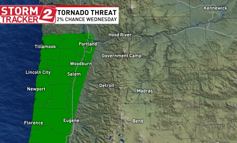
On Tuesday, the Storm Prediction Center said there was a 2% chance of seeing a tornado within a 50-mile point of any city within a shaded area including much of the Portland metro area and the Oregon Coast. That percentage remains the same today.
“Keep in mind that the Storm Prediction Center places only a Marginal Risk (level 1 out of 5) for significant wind or tornadoes for our area today,” Storm Tracker 2 Meteorologist Rhonda Shelby said. “However, a strong front, with strong dynamics, and plenty of moisture means isolated, or “one-off” intense cells can still happen on Marginal Risk days.”
“If you see a funnel cloud or a tornado, or if a Tornado Warning or a Severe Thunderstorm Warning is issued for your area, you should go to an interior room on the lowest floor of your residence,” NWS Portland said.
“Stay ‘weather aware’ through the afternoon as this disturbance comes through. Lightning, sudden wind bursts, and heavy rain are all still on the table,” Shelby added. The Storm Tracker 2 Weather team will continue to track any storms that form.
Download the Storm Tracker 2 Weather App so you have the latest watches and warnings sent directly to your phone.
A Tornado Warning was issued for parts of Pacific County in Washington until 5:15 p.m., according to NWS.