A break from the unsettled weather
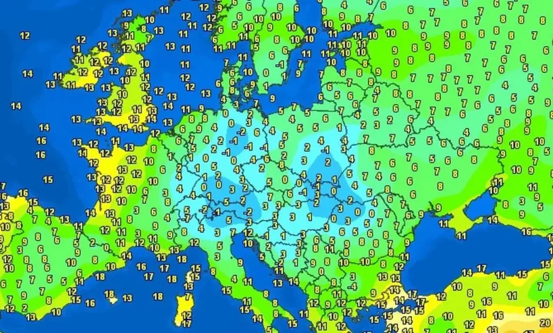
Temps across Europe today (Image: WXCHARTS)
There is some good news amongst the heavy rain and gloom that”s settled over the coountry over the last while – Cork and Munster will be far warmer than Madrid and Central Spain today.
We can expect highs of around 15C on the south coast today, around 8C higher than they will see in the Spanish capital and well above the average for Munster for November. And there are also some clear skies on the way with the very heavy rain overnight and early this morning to start clearing away to give us a brighter, dryer afternoon.
This weekend should also bring us clearer skies on Sunday, with a chance of mild temperatures and prolonged sunny spells – a great day to get out and do some late-autumn hiking in the woods. However, once we get to Monday and into next week, the very heavy showers and dark clouds will return for another week of very unsettled weather.
The full forecast for Munster this morning looks like:
TODAY – Friday 7th November
Dull on Friday with outbreaks of rain and drizzle. A more persistent band of rain across the southwest of the province will push northeastwards during the morning. However, a clearance to scattered showers and sunny spells will follow into the afternoon. Highest temperatures of 13 to 15 degrees in moderate southeast winds, veering westerly after rain passes through.
TONIGHT
Generally dry tonight under broken cloud with some mist patches. A little showery rain will feed into western areas later. Cool with lowest temperatures of 4 to 9 degrees, in light southerly or variable breezes.
TOMORROW – Saturday 8th November
Rather dull starting out on Saturday with patchy outbreaks of rain, turning heavier and persistent through the afternoon and evening along with freshening southerly winds. Some hill, mist and coastal fog too. Highest temperatures of 12 to 14 degrees.
National Outlook
Overview: Further spells of rain but sunny spells at times too.
Saturday night: Wet and breezy with widespread rain, heavy at times. Lowest temperatures of 8 to 11 degrees, in a moderate to fresh southerly wind.
Sunday: Beginning cloudy with some scattered falls of rain and drizzle, soon clearing northeastwards. Mostly dry weather will follow for the rest of the day with sunny spells breaking through. Highest temperatures of 12 to 14 degrees, in light to moderate southwesterly winds. Mostly dry and calm overnight but with some mist and fog, mainly across eastern areas. Chilly too with lowest temperatures of 3 to 6 degrees.
Monday: Crisp sunshine to begin but with areas of mist and fog across eastern areas. Some uncertainty – while many areas will remain dry with sunny spells, some showery rain may affect south and southeast areas. Highest temperatures of 10 to 13 degrees, in light to moderate southeasterly winds.
Tuesday: Current indications suggest it will be a wet and blustery day. The rain will be heavy and persistent with spot flooding. Hill, mist and coastal fog too. Highest temperatures of 12 to 14 degrees, in brisk south to southeast winds.
Unsettled with a large and complex area low pressure in the nearby Atlantic feeding up further spells of rain or showers.