Snow Squalls Take Aim at London, Barrie and Northern GTA on Sunday With Up to 25-50cm of Snow Possible
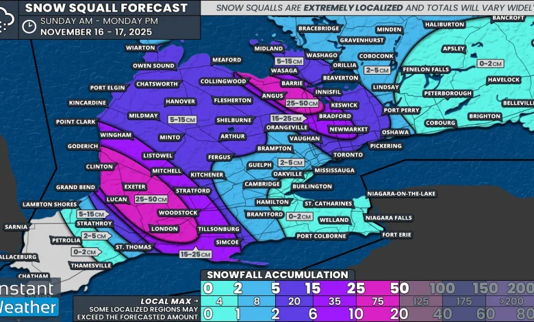
Snow squall forecasting always comes with big caveats. The bands are extremely narrow, which means the difference between 50cm and almost nothing can be only a few dozen kilometres.
This is why we provide a broad range. They help capture that uncertainty, but they are not a guarantee. With this event, the bands appear very intense but also very narrow, which means gradients will be sharp.
Based on the latest data, we expect the hardest hit areas from the Lake Huron squall to include Goderich, Clinton, Lucan, Exeter, Mitchell and London. Snowfall totals here could range from 25 to 50cm, with the chance that someone ends up over 50cm in a very localized spot.
Surrounding regions, including Grand Bend, Tillsonburg, Stratford, Wingham, and Point Clark, could see 15 to 25cm.
Further east into Grey Bruce and Dufferin County, we are expecting 5 to 15cm mainly on Monday as the lake effect shifts northward.
The Georgian Bay band looks even narrower than the Lake Huron band. A small corridor stretching from Collingwood through Angus and into Innisfil could see 25 to 35cm, with a chance of 50cm if the band really intensifies.
The City of Barrie is right on the edge. A small shift north or south would bring very different results. For now, the highest totals look likely in the south end of the city with 15 to 30cm. The north end may be closer to 10 to 20cm.
Substantial totals may also extend into the Northern GTA, including Bradford, Newmarket and Aurora. Totals along the Highway 400 and 404 corridor could range from 15 to 30cm.
Across the east end of Toronto and Durham, including Ajax, Pickering and Oshawa, occasional heavy bursts may bring 5 to 10cm.
The rest of Southern Ontario should see less than 5cm of snow by Monday from the lake effect.