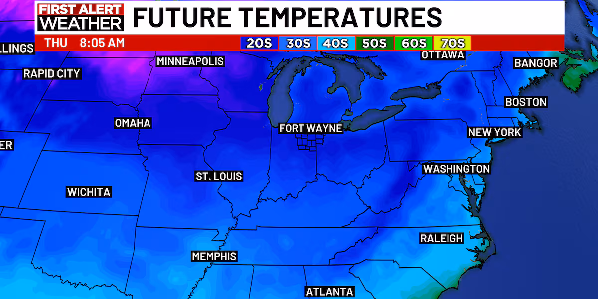
ITHACA, N.Y. — Folks in the hills north and east of Ithaca will need to have their snow shovels handy over the next couple of days as lake-enhanced snow bands continue, while many valley and lakeshore areas of Tompkins County will stay rain for most of the precip event. High pressure coming in mid-week will allow temperatures to warm back to normal or even above normal values, and although Friday looks damp, it should be a rain event for all of Greater Ithaca. As folks gear up for their holiday travel next week, no major weather disruptions are expected locally at this time, but depending on where you’re going, your mileage may vary.
Graphic courtesy of NWS Binghamton.
Your Weekly Weather
A strong storm system is slowly moving NNE’ward from the Gulf of Maine into Atlantic Canada today. Between its wraparound oceanic moisture and the instability caused by both its broader circulation and the cold air passing over the waters of Lake Ontario, widespread if narrow bands of rain and snow showers are stretched across Upstate New York this afternoon. With a steep pressure gradient between the low and a strong high over the Dakotas, Winds will be whipping from the NW across much of Upstate today, with Tompkins County seeing gusts of 40-50 MPH through the evening.
Generally speaking, lake-enhanced snowfall will be stronger north and east of Ithaca where the NW-SE bands are able to better tap Lake Ontario’s energy, and weaker to the south and west of Ithaca where the winds coming across the water are less able to tap the heat energy of the lake surface. Ithaca itself can expect an inch or so of snow between now and Wednesday morning, but the hillier parts of Groton, Lansing and Dryden could easily see 3-6 inches of snow during the same period, as what falls from the sky will be very elevation-dependent with temperatures right around 32 F.
The Atlantic low will slowly pull away Monday night into Tuesday, allowing high pressure to build in from the west and shut down any ongoing precip. As the core of that high continues to migrate eastward later in the week, its clockwise circulation will bring milder air into Tompkins County. However, a pair of low pressure systems, one passing to the north and one to the south, will bring in rain showers for Thursday night through Friday.
For the remainder of your Sunday, expect blustery northwest winds and a mix of rain and snow showers, primarily rain in valley areas and snow at higher elevations, becoming all snow showers after sunset. Highs will be in the lower 40s. Tonight will see the winds abate somewhat, with overcast skies and another coating to an inch of snow for many areas as the storm system lingers to the east. Lows overnight will be in the upper 20s, but will gusts will make it feel more like the upper teens.
Monday will be a similar day, though rain and snow showers will weaken as the low begins to pull away, and winds will also be weaker if still breezy. New accumulations will be light as will any rain that falls, and highs will be in the upper 30s with near-overcast skies. Monday night will see a few snow showers early, winding down after midnight. Skies will be mostly cloudy with lows in the upper 20s.
Drier weather takes hold Tuesday as the high pushes in from the west. It will be partly cloudy with light northwest winds and highs in the lower 40s. Tuesday night will be partly cloudy with perhaps a snow shower or two north of Ithaca, with lows in the lower 20s.
With the core of the high moving overhead Wednesday, northwest winds will wind down and the relative calm will allow temps to perk up. It will be partly cloudy with highs in the mid to upper 40s. Wednesday night will see a gradual increase in clouds if still dry, with lows in the upper 20s.
A dry if overcast day is on tap for Thursday, as the high shifts eastward and the cloud shield builds in well ahead of the cores of the low pressure systems to the northwest and southwest. With south winds, highs will be in the upper 40s. Thursday night will see rain showers after midnight with lows around 40.
The two lows work in tandem Friday to create ample south winds, and the result will be a mild if rainy end to the work week, with periods of light to moderate rain and highs in the mid 50s. Friday night will see rain showers gradually taper off as winds turn to from the northwest after midnight, with lows in the upper 30s.
Looking ahead into next weekend, another bubble of high pressure moves in behind the departing lows Saturday. Some AM showers are likely, and becoming drier later in the day, with mostly cloudy skies and highs in the low 50s (I will note a fairly wide range in temperature forecasts, with anywhere from mid 40s to mid 50s possible for highs Saturday). Sunday looks to be dry as a system is expected to pass too far to the north to impact Tompkins County, and highs will be around 50. Lows are likely to be in the mid 30s both days.
Graphics courtesy of the NOAA Climate Prediction Center.
Extended Outlook
Looking ahead into the week of Thanksgiving, the large scale pattern favors a jet stream trough over the West Coast, and a downstream ridge over much of the Eastern U.S. With the dominant jet stream branch (storm conveyor belt, if you prefer to think of it that way) becoming the subpolar latitudes, cooler air and northern Pacific storms will be brought down through Western Canada into the Northern Plains, with additional moisture brought northward from the Gulf of Mexico. On the fringe of that in Tompkins County, slightly above normal precipitation is likely along with milder than normal temperatures as we go through the busy travel week, while California gets a chance to dry out from its latest atmospheric river.
I would be remiss if I did not point out that some early indications of a cold snap in early December are showing up in observational data (a sudden stratospheric warming event is underway over the North Pole), but it’s too early to make any explicit statements.