Residents in Australia’s north are being warned a tropical low looming off the coast could develop into a category two cyclone within days.
Eyes remain fixed to northern Western Australia and the Northern Territory as a tropical low develops over the Timor Sea.
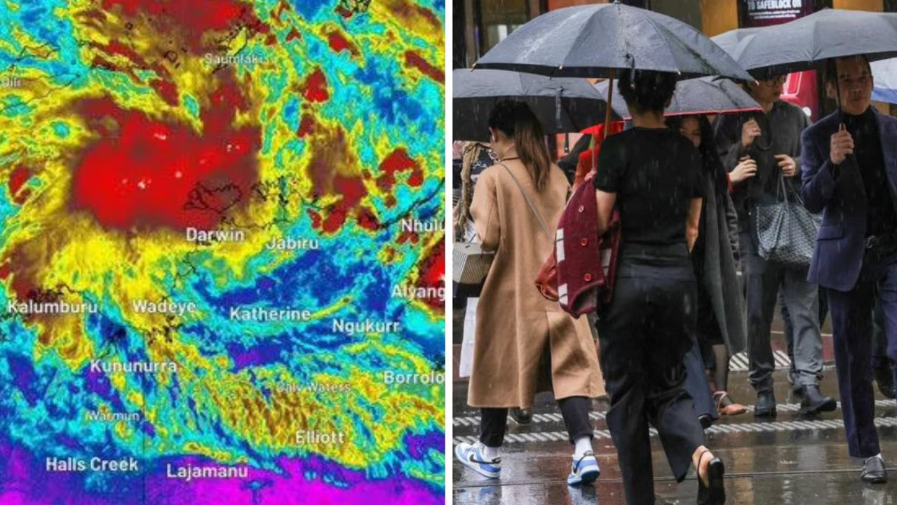
The Bureau of Meteorology said the tropical low, dubbed 02U, is currently located about 250km northwest of Darwin and was travelling slowly on an east to northeast track.
The current conditions in the northern part of the country are “favourable” for cyclone development, meaning tropical low 02U could develop into a category two tropical cyclone as early as Thursday afternoon.
It would then be known as Tropical Cyclone Fina.
“It is quite a broad mass of just cloud and storms at the moment, but over the last day or so, we have started to see a circulation develop and showing … signs of strengthening,” senior meteorologist Jonathan How told NewsWire.
“(It) is expected to continue strengthening over the next few days.”
Water temperatures have remained unseasonably warm in the past few days, priming the region for a tropical cyclone.
Last week, Weatherzone reported a “blob” of warm water to the northwest of Darwin, with sea temperatures tipping past 31C.
These conditions are well above the minimum temperature of 26.5C required for a cyclone to form.
Tropical cyclones typically develop between November and April, though cyclones usually start until much later in the season.
While there is an average of 10 cyclones per season, according to the Bureau of Meteorology, only three or four usually make landfall.
Mr How told NewsWire while tropical cyclone season officially kicks off on November 1, the 02U tropical low was coming in “very early”.
The bureau doesn’t anticipate developing tropical cyclones until “late December”.
The last time a tropical cyclone developed this early was Cyclone Alessia, which made landfall in the Northern Territory on November 28, 2013.
“If (tropical low 02U) does make landfall in the next week or so, (it will be) the earliest Northern Territory crossing since we started recording back in the 1980s,” Mr How said.
“So it’s about a month early.”
Although there is no guarantee the tropical cyclone will make landfall, the bureau said the tropical low is expected to turn south on Thursday afternoon, before turning southwest towards the northern coast of the Northern Territory.
“We’re … expecting potential for very heavy rain, damaging winds, and a large storm surge,” Mr How said.
Elsewhere in the country, conditions are forecast to be much calmer, albeit a bit cooler than normal for this time of year.
The tropical low passing over Darwin is “stealing all the tropical moisture away from Queensland”, meaning residents can expect plenty of cloudy and overcast skies and a potential storm or two through the week.
Residents in Sydney will be handed a mixed bag of weather, ranging from warm and sunny days to stormy and wet conditions.
“We do see the potential for storms and some showers for Sydney later this weekend towards the weekend,” Mr How said.
“But nothing too crazy at this stage.”
Further south, conditions are gloomy and chilly as a cold front moves over Victoria and Tasmania, bringing rain and icy temperatures.
“Unfortunately for those in Melbourne, it will mean a return to winter-like conditions on Thursday, back to just 16C and showers,” Mr How told NewsWire.
“The good news is that we do see some warmer weather return to Melbourne and the southeast towards the weekend.”
Weather will remain settled in South Australia for the week, although temperatures are forecast to be below average.
The same cannot be said for Perth, which is forecast to see storms and showers southwest of the state over the next few days.