There’s a Met Office yellow weather warning for snow and ice
Shannon Brown Reporter and Maxine Denton Senior Reporter
11:22, 19 Nov 2025
Snow has arrived on Dartmoor
Snow has arrived in Devon with a light dusting on Dartmoor as other parts of the county can expect a flurry in the next 24 hours.
A yellow weather alert has been issued for the South West, with snow and ice forecast in the coming days, according to the Met Office.
Throughout Wednesday and Thursday, wintry showers will feed southwards across southwest Wales and parts of Devon and Cornwall, with a yellow alert in place from midday today (November 19).
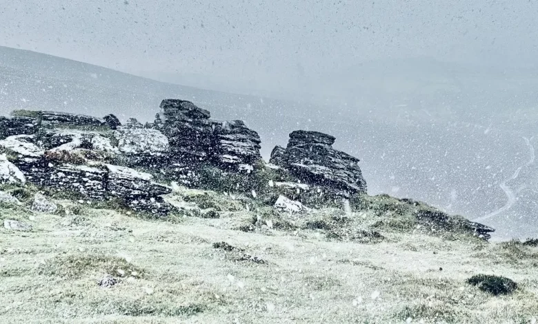
According to the Met Office weather maps, parts of Dartmoor have already seen snowfall through the morning, as captured on camera by local resident Mark Shackleton, but more flurries are expected from around 3pm.
As usual, the bulk of the snow is going to fall in Dartmoor, between Tavistock and Okehampton. Mark said there was a light dusting this morning but it did not settle for long.
Snow is set to fall across parts of Devon – largely Dartmoor(Image: Met Office)
Outbreaks of hail will also move across the county through out the day, with brief snowy showers falling in between.
At 4pm, Moretonhampstead is set to see a heavy dusting, before it’s blown southwards and becomes hail just before Totnes.
The Devon-Cornwall border is set for its own blanket of snow at around 6.30pm, with some flurries expected within a large area of hail between Okehampton and Launceston. This will pass south over Tavistock and turn to rain as it reaches Plymouth, according to the Met Office weather maps.
Small areas of the white stuff are predicted to move across the county overnight, though each is expected to turn to hail or rain as it reaches the south Devon coastline. At around 1.30am on Thursday, November 20, Okehampton is set to get another spell and Lifton should see some more at around 3am.
At 5am on Thursday, a larger and heavier patch is expected to fall over Dartmoor, with more than 4mm of the white stuff expected in the heart of the moors. Great Torrington may also see a bit of snow, as will Tiverton.
Each snowy spell is likely to be brief and may not settle because of the persistent rain and hail which is also expected in the region.
A heavy band of hail in North Devon is set to develop into snow as it moves inland, turning heavy over Holsworthy and Launceston at around 7.30am. As the day wears on, snow will turn to rain and hail showers.
Temperatures are expected to reach highs of around 6-7C but will drop overnight to below freezing.
This blast of polar air from the north will mark the first major cold snap for autumn, with temperatures set to plummet as the week continues.
Met Office Chief Forecaster Neil Armstrong said: “As a result, winter hazards are likely through the next few days, with snow and ice a particular hazard, and the coldest conditions likely on Wednesday and Thursday,” he said.
“Some snow accumulations will be possible in places … whilst some places will see little or no lying snow, (in areas) where showers are most frequent, accumulations of two to five centimetres are possible.”
Snowfall in England could even reach “perhaps up to 10 centimetres in a few isolated spots”, with the South West region earmarked as a possibility.
Gusty winds, hail, and even icy conditions may also occur, with Mr Armstrong adding: “Temperatures are well below average for the time of year .. with clear skies, overnight ice could create some particularly tricky travel conditions.”