What is the polar vortex? How it can impact snow, freezes in the U.S.
The polar vortex is a large area of circulating cold air above the North Pole. Strong winds keep it contained, but when it weakens, it can wobble and stretch.
- An arctic blast is expected to bring cold temperatures and potential heavy snow to Ohio and other parts of the U.S. around Thanksgiving.
- Travelers should anticipate delays on Tuesday and Wednesday before Thanksgiving as a storm system moves through the Midwest and Northeast.
- Forecasters are monitoring a rare atmospheric event called a sudden stratospheric warming, which could weaken the polar vortex and lead to a significant cold outbreak.
- Ohio’s Thanksgiving forecast includes dry but cold conditions, with a growing chance for lake-effect snow.
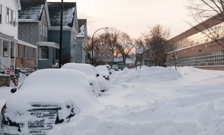
Another arctic blast is on the move toward the U.S., bringing the potential for bitter cold and heavy snow accumulations to Ohio — possibly beginning during the Thanksgiving holiday weekend and lasting into early December.
It’s unclear whether the forecast event will be as intense as the Nov. 10 system that left more than a foot in Buffalo and Michigan and delivered the first heavy snow accumulation in Ohio. However, the cold is unlikely to reach as far south as it did when record-breaking temperatures hit parts of Florida.
Regardless of its development, there are several storm systems set to impact much of the U.S. throughout the week, forecasters said.
Will Ohio travel be impacted by bad weather?
Thanksgiving is the busiest travel holiday, according to AAA’s 2025 holiday forecast, with 82 million Americans traveling via road, air or rail.
At this point, the storm will primarily be a rainmaker, though some snow is possible along its northern edges.
“A storm will impact much of the eastern two-thirds of the United States during the busiest travel times ahead of the Thanksgiving holiday as millions hit the highways and head for the airports,” said AccuWeather meteorologist Alex Sosnowski.
AccuWeather meteorologist Bernie Rayno said to expect travel delays on Tuesday, Nov. 25, and Wednesday, Nov. 26, as the storm rolls through the Midwest and into the Northeast.
According to the forecast, the storm will likely come out of Texas and into the Midwest from Tuesday into Wednesday, covering an area from northeast Texas through Arkansas, eastern Missouri and the southern half of Illinois.
“So there’s going to be some travel delays across the central part of the United States,” he said. “There could even be some strong to severe thunderstorms.”
By Wednesday, Nov. 26, “the storm will be losing some of its intensity and moisture as it travels from the central states to the Northeast, but given the travel volume, even a few hours of rain can create significant problems on the roads and runways from Washington, D.C., to Philadelphia, New York City and Boston,” noted AccuWeather meteorologist Paul Pastelok in an online forecast.
‘An extraordinary and unique event’ could be brewing
Experts say an unusual stratospheric pattern, known as sudden stratospheric warming, could also come to fruition next week, potentially reshaping winter weather across the Northern Hemisphere if it develops.
The polar vortex — a band of frigid arctic air circling the North Pole 10 to 30 miles above the surface —normally keeps cold air contained near the pole. When sudden stratospheric warming weakens the vortex, it stretches unevenly, letting cold air spill south. The jet stream then determines where that air moves, influencing U.S. winter conditions.
Climatologist Judah Cohen of MIT said the atmosphere is “at a critical juncture,” noting that November could be a “fork in the road” for the rest of winter. If this warming occurs, it would be the first November event on record since satellites began monitoring, making it “extraordinary, even unique,” he said.
While it’s still too far out to determine, chances are increasing for a return of the arctic blast and a noticeable shift in the weather pattern.”
“Following a warm start to November in the West and a cold start in the East, the combined effects from (several weather conditions) may usher in a significant pattern change later in the month and into early December,” the Climate Prediction Center wrote. “During Thanksgiving week, a colder pattern is likely for the West and the Northern Plains while milder air overspreads the East. A transition to a colder pattern is then forecast across much of the central and northern U.S. into early December.
“This pattern change favors a transition to more winter-like conditions across the west-central and central U.S. including much below normal temperatures and the potential for heavy snow,” the CPC added.
According to the Climate Prediction Center, the Madden-Julian Oscillation (MJO) — a moving pattern of thunderstorms in the tropics — can influence how cold or warm air shifts across the U.S. La Niña — a cooling of the tropical Pacific Ocean — tends to push arctic air farther south, increasing the chance of cold outbreaks across the northern states.
Combined, the patterns are likely to mean an “increased cold air intrusion across the northern tier of the contiguous United States” over the next couple weeks, the forecast states.
Ohio weather forecast for Thanksgiving
As of Thursday, Nov. 20, Ohio’s Thanksgiving forecast calls for dry conditions across much of the state, though temperatures ranging from the upper 20s to the upper 30s may support the potential for lake-effect snow, which has growing chances of occurring, according to the Climate Prediction Center.
Some rain is possible closer to the Great Lakes.
“Anticipated gusty winds combined with snowfall could support blowing snow and resulting decreased visibility, especially across parts of the Northern and Central Plains during the Thanksgiving travel period,” meteorologists wrote in the forecast. “There could be some wrap-around lake-effect snow across the southern Great Lakes but [it is] difficult to determine at this time.”
Across the country, regardless of the arctic blast, AccuWeather meteorologists are predicting major travel disruptions as a storm system is set to batter much of the western United States and Midwest with heavy snow and cold rain over the holiday. The Northeast will see mainly rain ahead of Thanksgiving Day.
On the back side of the Thanksgiving storm system, gusty winds are forecast to spread from the Great Lakes into the Northeast, impacting air travel, airports, and high-profile vehicles. Dangerously high wind gusts could affect events like the Macy’s Day Parade in New York City and the Dunkin’ Donuts Thanksgiving Day Parade in Philadelphia.
What does the polar vortex look like right now?
Right now, charts show the polar vortex is unusually weak and is likely to send temps plunging across the U.S. beginning early next week.
This weakness is linked to very low winds high above the arctic, called zonal winds, which are now declining and approaching 0 m/s, a threshold that can trigger an event called major sudden stratospheric warming (SSW). These events often lead to significant cold outbreaks and even blizzards.
(Note about graphs: The dashed 0 m/s line marks the boundary between westerly winds (above the line), which represent a normal, intact stratospheric polar vortex, and easterly winds (below the line), which indicate a reversal of the vortex and meet the definition of a major sudden stratospheric warming if sustained. In the initial graph, on Nov. 1, the forecast members (blue lines) are at the top of the chart, signaling a strong polar vortex. In the latter graph, many forecast members (blue lines) dip toward or below 0 m/s in late November, showing the potential for a significant weakening or even reversal of the 10 hPa zonal winds, compared with the typical climatological values shown in red.)
The vortex’s instability is also influenced by the Quasi-Biennial Oscillation (QBO), a stratospheric wind pattern that shifts between easterly and westerly roughly every 28–29 months. When the QBO is in its easterly phase, as it is now, the vortex is more prone to wobble south.
Meanwhile, a weak La Niña in the lower atmosphere is shaping winter patterns as well. While it doesn’t directly affect the polar vortex, it can shift the jet stream, influencing where arctic air travels and how long cold outbreaks linger. La Niña may also leave large bodies of water unfrozen, increasing the risk of lake-effect snow in the Great Lakes when arctic air moves over open water.
What is lake-effect snow?
Lake-effect snow typically happens when cold, dry arctic air moves over a large, relatively warm lake, creating narrow bands of clouds that can dump snow anywhere from a few minutes to several days.
Wind direction also matters a lot — it can mean heavy snow in one town while a sunny mile or two away sees nothing:
- Westerly winds: These are common across northern Ohio. When cold air moves from the west over Lake Erie, it picks up moisture and warmth from the lake. As the air reaches land, that moisture condenses and falls as snow, often in narrow, heavy bands.
- Northwesterly winds: These can boost snowfall across northeast Ohio, including areas along the southern and eastern Lake Erie shoreline.
Ohio weather watches and warnings
Stay informed. Get weather alerts via text
Brandi D. Addison covers weather across the United States as the Weather Connect Reporter for the USA TODAY Network. She can be reached at baddison@gannett.com. Find her on Facebook here.