The atmosphere is primed for intense thunderstorms over southeast Queensland and northeast New South Wales on Monday, with a risk of supercells bringing destructive winds and giant hail.
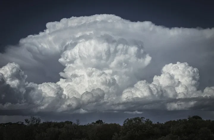
Parts of southeast Qld were hit with massive hailstones on Sunday as severe storms swept over eastern Australia. This included hail measuring around 8cm in diameter to the south of Brisbane, caused by a supercell that roared across the Scenic Rim and Logan regions shortly after sunset.
Image: A supercell passing over parts of southeast Qld on Sunday evening. Source: Weatherzone.
Monday has all the ingredients for further severe thunderstorm development over northeast NSW and southeast Qld. Computer models suggest populated areas in both states could see severe storms in the afternoon and evening.
The three main ingredients for thunderstorms are:
- Instability
- Moisture
- Trigger
Atmospheric instability will be abundant over southeast Qld and northeast NSW on Monday due to warm air near the surface and much cooler, drier air aloft. This instability will provide the lift required to build large thunderstorm clouds stretching thousands of metres into the sky.
There will also be plenty of moisture available in the lower and middle levels of the atmosphere, providing ample fuel for storm clouds to become loaded with rain and hail.
There will also be two main triggers for storms on Monday. The first will be a ‘dry line’ sitting over southeast Qld and northeast NSW, which is a zone where moisture-laden air to the east clashes with drier air to the west. The second trigger for storms will be a southeastern wind change moving towards the north throughout the afternoon and evening.
One additional ingredient that will help make Monday’s storms particularly dangerous is wind shear, which refers to the change in wind speed and direction with height. Strong wind shear over southeast Qld and northeast NSW will help create rotation in thunderstorms, increasing the likelihood of supercells, which are the most violent and dangerous type of thunderstorm.
Storms on Monday should initially form over northeast NSW in the afternoon before spreading into southeast Qld during the afternoon and early evening.
Monday’s severe thunderstorms are likely to cause heavy rain, damaging wind gusts in excess of 90 km/h and large hail measuring larger than 2cm in diameter in some areas. If supercells develop, wind gusts exceeding 125 km/h and giant hail exceeding 5m will also be a risk.
Image: Forecast accumulated rain on Monday, showing the general region where thunderstorms are expected to occur according to the ACCESS-C model. Source: Weatherzone.
Severe thunderstorm warnings are likely to be issued and updated throughout the afternoon and evening, so be sure to check the latest warnings in your area and keep an eye on the radar to see where storms are moving.
Thunderstorms will affect parts of Qld every day this week and storms will also be a regular feature in several other Australian states and territories throughout the week. Brisbane and other areas of southeast Qld and northeast NSW could see potentially severe storms every day between now and at least Thursday.