Thanksgiving Travel Forecast For The U.S.
Thanksgiving week has arrived. Unfortunately, the weather may not cooperate in parts of the country, especially the weekend after the holiday.
Here’s what you need to know for the weather forecast:
Monday
Major airports that could be impacted during the day: Dallas, Houston, Kansas City
Fog: Areas of fog will blanket parts of the Midwest, Deep South and a few areas of the West. In most of these areas, the fog should lift by mid-morning, so this may only affect the morning commute or any morning flights in Louisville, Nashville, Sacramento, St. Louis or Tampa.
Soaked central: Rain is expected from Texas and Louisiana to the upper Mississippi Valley. Flooding rain and a few severe thunderstorms are possible from Texas to Arkansas, northern and western Louisiana into Mississippi. Watch for flooded roads and leave extra time to get to your destination. This may lead to thunderstorm-related flight delays at Dallas-Ft. Worth and eventually, Houston.
Northern Rockies snow: Some snow and increasing winds are possible in parts of the Northern Rockies that could lead to slippery roads, especially over mountain passes.
(For even more granular weather data tracking in your area, view your 15-minute details forecast in our Premium Pro experience.)
Tuesday
Major airports that could be impacted: Atlanta, Chicago, New York City, Philadelphia, Seattle, Minneapolis (late), Washington, D.C.
Fog: Once again, there could be areas of fog to deal with Tuesday morning, this time up and down the Eastern Seaboard from the Northeast to Florida, but as well in parts of the Midwest. This could lead to morning flight delays at many major East Coast hubs, as well as Chicago.
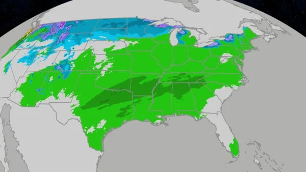
More widespread rain for the eastern half of the U.S.: Rain is expected to spread from the Midwest and Southeast early to the East Coast by the end of the day. Some thunderstorms are possible across the Southeast in the areas shaded in darkest green above.
Snow in the Northern Plains: Wind-driven snow is expected in parts of the Northern Plains from parts of the Dakotas into northern Minnesota. This could lead to challenging travel on Interstate 94 northwest of the Twin Cities into North Dakota and Interstate 29 in North Dakota and northeast South Dakota. Rain may turn to snow in the Twin Cities Tuesday night, leading to some slippery travel.
Northwest, again: Another storm system may bring rain and mountain snow to Washington and Oregon, then into northern Idaho and far western Montana late.
Wednesday
Major airports that could be impacted: Boston, New York City, Philadelphia, Seattle, Washington, D.C.
Rain may linger in East: For the peak travel day, showers may flare up ahead of a cold front in at least parts of the East That could lead to some flight delays out of the major Northeast hubs.
Lake-effect snow: Heavy lake-effect snow and strong winds will spread from the western Great Lakes snowbelts (northern and western Michigan, northern Wisconsin) Wednesday into the eastern lake snowbelts (northeast Ohio, northwest Pennsylvania, southwest New York, upstate New York) overnight Wednesday night. Expect dangerous travel in these areas.
Northwest still wet: Pacific Northwest rain and northern Rockies snow are expected, which could lead to slippery roads, particularly over mountain passes. This Northwest system could be an atmospheric river event with locally heavy rain possible in parts of western Washington and Oregon.
(192-hours: Further beef up your forecast with our detailed, hour-by-hour breakdown for the next 8 days – only available on our Premium Pro experience.)
Thanksgiving Day’s Forecast
Thanksgiving Day
Major airports that could be impacted: Seattle
Lake-effect snow: Bands of heavy lake-effect snow and strong winds will continue in the Great Lakes snowbelts. Expect whiteout conditions in these narrow, localized lake-effect bands affecting stretches of Interstate 90 from Cleveland to near Buffalo, Interstate 81 north of Syracuse, New York, Interstates 80/90 in northern Indiana and Interstates 94 and 196 in western Michigan.
Rain and snow for Northwest: Snow may blanket the northern Rockies and possibly the adjacent High Plains of Montana. In the Pacific Northwest, expect some showers and possibly strong winds in western Washington and Oregon.
Black Friday
Major airports that could be impacted: Dallas-Ft. Worth (late), Houston (late), Kansas City
Another day of lake-effect snow: Lake-effect snowbands will persist, especially in the eastern and northern Great Lakes snowbelts, with dangerous travel likely. Some other wrap-around snow showers are possible in northern New England.
More Northern Plains snow: Snow will spread out of Montana into the Northern Plains from the Dakotas to the Missouri Valley. Friday night, that snow may spread into parts of the upper Midwest.
More South storms: Showers and thunderstorms may break out Friday night from Kansas and southern Missouri to Texas and Louisiana. Some of those may have heavy rainfall and could lead to nighttime flight delays at the major Texas airport hubs.
Saturday
This forecast has considerable uncertainty. Check back with us at weather.com for the latest forecast updates.
Major airports that could be impacted: Chicago, Detroit, Dallas-Ft. Worth, Houston, Kansas City
Midwest wintry mess: Snow, possibly some sleet and freezing rain, may move through parts of the Mississippi Valley and Great Lakes. This could lead to both slippery roads and flight delays, including at Chicago-O’Hare and Detroit.
South storms: Thunderstorms with heavy rain, and some possibly severe, may rumble across the South from Oklahoma and Texas to the lower Mississippi Valley. This could lead to local flash flooding and flight delays at both Dallas-Ft. Worth and Houston.
Rockies snow: At least some light snow is possible in the Rockies possibly as far south as Colorado or New Mexico.
Sunday
This forecast has major uncertainty right now. The map above shows our current forecast.
Right now, weather forecast models vary widely in Sunday’s weather across the country, ranging from East Coast rain and northern New England snow, with little else, to a mess of snow and thunderstorms in the central U.S., showers in the Southwest and a dry East.
Check back with us at weather.com for the latest forecast updates in the coming days as this forecast comes into focus.