UK weather: Britain braces for chaotic week with snow, wind, rain and… warmer temperatures
Battling weather systems threaten a chaotic week of wind, rain and snow as temperatures yo-yo between sub-zero and double figures.
Atlantic gusts will hit parts of the country though the next couple of days driving heavy downpours and the risk of gales.
High pressure nudging in mid-week could then reopen the Arctic gates, pushing the mercury in parts to back to -5C.
Yet another U-turn this weekend will bring a wet, windy but mild end to November as thermometers head back up.
Met Office meteorologist Annie Shuttleworth said: “We are expecting some milder wetter weather after a potentially drier period through the middle of the week, particularly for western areas.
“But then it will return to a wetter, milder and more changeable set up for the end of the week and the weekend.
“We have low pressure out to the west of the UK bringing in milder, wetter and potentially windier weather by the end of the week.”
While mid-week promises a brief respite from the rain, a shift in high pressure will draw in a northerly.
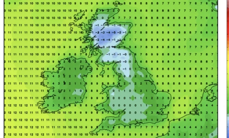
High pressure nudging in mid-week could then reopen the Arctic gates, pushing the mercury in parts to back to -5C
|
NETWEATHER
Temperatures will stay higher than the Polar lows of last week, although Scotland and northern England will dip below freezing with the risk of snow.
Jim Dale, meteorologist for British Weather Services and co-author of ‘Surviving Extreme Weather’, said: “We get a bit of a northerly again through the middle of the week, but rather than what we have seen, it will be confined to the north where the snow there might be a bit stubborn.
“This will drag cooler air down across the country, but again, we are not looking at the same temperatures as last week.”
Wind and rain will return ahead of the weekend as November closes with a turbulent blast from the Atlantic, he added.
Temperatures towards the end of the week are likely to hit double figures under the influence of mild Atlantic winds
|
NETWEATHER
He said: “The doors to the Atlantic are going to open again, and this is going to bring the risk of wind and rain to parts of the country.
“There are going to be many places that stay dry, but where it does rain, it could be heavy at times.
“We are looking at a bit of reversal to where we were a couple of weeks ago.”
A “blocked” weather pattern wedging cyclonic low pressure off the UK coast could keep the taps on over eastern counties while the west enjoys a drier spell.
Temperatures towards the end of the week are likely to hit double figures under the influence of mild Atlantic winds.
Shuttleworth said: “There is a chance that the pressure patterns become blocked with low pressure remaining centred to the east of the UK which would mean some continuous rain across some eastern areas and higher pressure to the west, so potentially a drier period for some western areas.
“We have relatively low confidence for the week, but we are expecting some milder wetter weather after a potentially drier period through the middle of the week, particularly for western areas.
“But then it will return to a wetter, milder and more changeable set up for the end of the week and the weekend.”