In brief: In today’s post we talk about the potential for storms this evening in Houston as a weak front sags into the area. A second push of colder air will make things feel festive on Thanksgiving Day. And we’ll see the return of a moderately warmer pattern with higher rain chances this coming weekend.
We begin today’s post with a little bit of housekeeping …
A few words on our app
Our app—which remains completely free and does not track your activity, in other words we do not monetize your data—is now a few years old. We went through some growing pains this year as both app platforms changed things up. Honestly, keeping up with everything in app-land is a lot, and so I’m glad we’ve got Dwight Silverman and Hussain Abbasi to manage all of it. There have been a fair few bugs and issues we had to slog through earlier this year, but I’m happy to report that everything has been working really well for the last couple of months. But don’t take my word for it, here’s a comment sent in by Lily Yee last week. We’re sharing it with her approval:
Hey! I just opened this app for the first time in several weeks (full honesty) and I was SHOCKED by the noticeable, significant improvement in loading speed & reaction time. To your web dev and design team – great job! 🙂 it makes a real difference on the usability. I’ll be putting this app on the front page of my phone screen now!
So if you haven’t downloaded the app, please do so now by clicking here. It’s fun, and free, and even sometimes the forecast is accurate.
Fundraiser
We’re now into the final week of our fundraiser, and I mentioned our app above because the reason we’re able to provide it, and update it, and keep it junk free is because of contributions from our readers. Your donations and purchase of merchandise now allow us to plan for next year. We want to continue iterating on the app (more on this soon) as well as make some other major upgrades like improving the distribution of our newsletter. If you can help out, please do so here.
Severe weather outlook for Monday and Monday night. (NOAA)
Monday
Our brief foray with cooler fall weather on Sunday has ended, with this weekend’s front moving back onshore as a warm front overnight. Winds this morning are light, from the southeast, with temperatures around 70 degrees. Accordingly, today will be rather warm, with highs in the low 80s despite mostly cloudy skies. We are going to see scattered (mostly light) showers during the daytime along with very humid air. By this evening, likely around 7 to 9 pm, a broken line of storms associated with a cold front will develop to the northwest of Houston. This line will slowly advance into the city during the late evening hours, and push off the coast after midnight. Damaging winds will be possible with this front, perhaps gusting up to 50 mph, with potentially some hail. Overall rain accumulations will vary widely, but most of us should pick up between 0.25 and 0.75 inch.
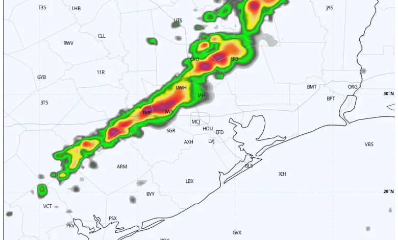
HRRR model forecast for radar reflectivity at 10 pm CT on Monday evening. For illustration purposes only! (Weather Bell)
Tuesday
The initial push of cooler air with with this front will be fairly weak. As a result I expect highs of around 80 degrees on Tuesday, with mostly sunny skies and lower humidity. Low temperatures on Tuesday night should drop into the 50s.
Wednesday
A secondary push of colder air arrives overnight, into Wednesday morning, and this will result in breezier northerly conditions. Winds may gust out of the north up to 20 mph on Wednesday. Expect sunny skies and highs in the upper 60s. Lows on Wednesday night will drop into the upper 40s in Houston, with cooler conditions for inland areas.
Thanksgiving morning should be the coolest of the week. (Weather Bell)
Thanksgiving
We’ll start the day clear and cool, and skies will be sunny throughout the day. Really, we have no weather concerns, with light winds expected and highs generally in the upper 60s. Lows on Thursday night will drop to around 50 degrees, with cooler conditions for inland areas.
Friday, Saturday, and Sunday
The onshore flow resumes on Friday, and we are going to enter a period of mostly cloudy skies and increased rain chances by Saturday morning. High temperatures through Sunday should be in the low- to mid-70s, with modestly increasing humidity levels. Overall I think the area will pick up 1 to 2 inches of rainfall on Saturday and Sunday. If you have outdoor plans we’ll keep a close eye on the forecast for you. At this point I think showers will be intermittent rather than wall-to-wall, but we don’t have a good handle on the details yet.
Next week
At some point, perhaps on Monday, a stronger front should push into the region. This is likely to bring some colder conditions, with lows perhaps down to around 40 degrees next week. It does appear as though the first week of December, which is the first week of winter as well, will probably feel decidedly winter-like in Houston. But for now the forecast is still a bit uncertain.