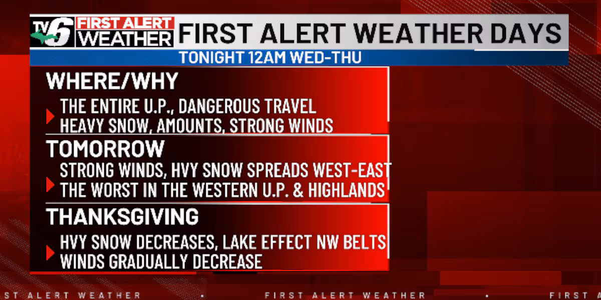
MARQUETTE, Mich. (WLUC) -A winter storm will bring heavy snow, high snowfall rates, and strong winds. It begins this evening and continues tomorrow, with impacts winding down on Thanksgiving.
TV6 First Alert Weather App> TV6 Apps for iOS and Android devices
Light rain transitions to snow in the Western U.P. this evening. Tomorrow morning, it’s snow in the west and rain in the central and eastern areas. The snow will transition from west to east across the U.P. tomorrow. Then, it decreases on Thanksgiving with moderate lake effect snow continuing in the Eastern U.P.
Plan on heavy accumulating snow and strong winds with gusts of 35-45mph and isolated 50mph. The worst conditions are expected in the Western U.P. and highlands tomorrow. These conditions will cause dangerous travel. Plan on heavy snow-covered roads and poor visibility!
Winter Storm Warnings will be in effect for most counties. We’ve issued First Alert Weather Days for Wednesday and Thursday as a result! Please, minimize travel tomorrow.
Current NWS Alerts>Alerts
Snowfall amounts will be high from tomorrow through Thanksgiving. The highest snowfall will range from 25-30″+ in the interior, Western U.P., and highlands. This includes the Keweenaw, Gogebic, Ontonagon, Baraga, Northern Iron, and Western Marquette counties. The shoreline of Lake Superior and Eastern U.P. will have less, at around a 12-15″. Along Lake Michigan, a range of 4-7+“ and 1-3″ in Menominee County.
Today: Cloudy with scattered rain and evening snow west
>Highs: Low to mid 40s
Wednesday: Widespread heavy snow and strong winds
>Highs: Mid 30s west, upper 30s to low 40s east
Thanksgiving: Moderate lake effect snow along the northwest wind belts
>Highs: Upper 20s inland, and low 30s along shorelines
Friday: Light lake effect snow showers in the north and colder
>Highs: Low 20s inland, upper 20s along shorelines
Saturday: Mostly cloudy with scattered snow
>Highs: Low 20s inland, upper 20s along shorelines
Sunday: Scattered snow and cold
>Highs: Low 20s inland, upper 20s along shorelines
Monday: Flurries north and cold
>Highs: Upper teens to low 20s
The video above will feature the TV6 livestream until staff can clip the corresponding story, if available, from broadcasts or other TV6 content. You can subscribe to our YouTube page or download TV6+ to stream the latest local news and weather.
Copyright 2025 WLUC. All rights reserved.