The storm system that started marching into Michigan on Tuesday night is flipping the switch to winter in a big way on Wednesday. Snow is going to develop rapidly today – and so are the winds.
Gusts are expected to ramp up to 40 to 50 mph inland today. Areas by Lake Michigan could see 60 mph winds.
These high winds will hit at the time of the heaviest snow, which is a combination expected to create hazardous travel conditions. Low visibility and near-whiteout conditions are expected in areas across the state today.
Temperatures will plunge to sub-freezing levels later Wednesday, making roads icy.
Wednesday afternoon into Thursday is expected to be the toughest time to be out on the roads.
“Travel conditions will worsen Wednesday afternoon/evening with slick and snow-covered roads and near-whiteout visibilities at times,” the National Weather Service in Grand Rapids said. “High winds are also expected with 40-60 mph gusts, highest along the Lakeshore.
“Conditions will deteriorate through the day Wednesday. Snow showers and hazardous conditions continue through Thursday before winding down Friday.
“If traveling for the holiday, allow extra time.”
Wednesday into Thursday will have the worst storm impact for Michigan.Graphic provided by the National Weather Service
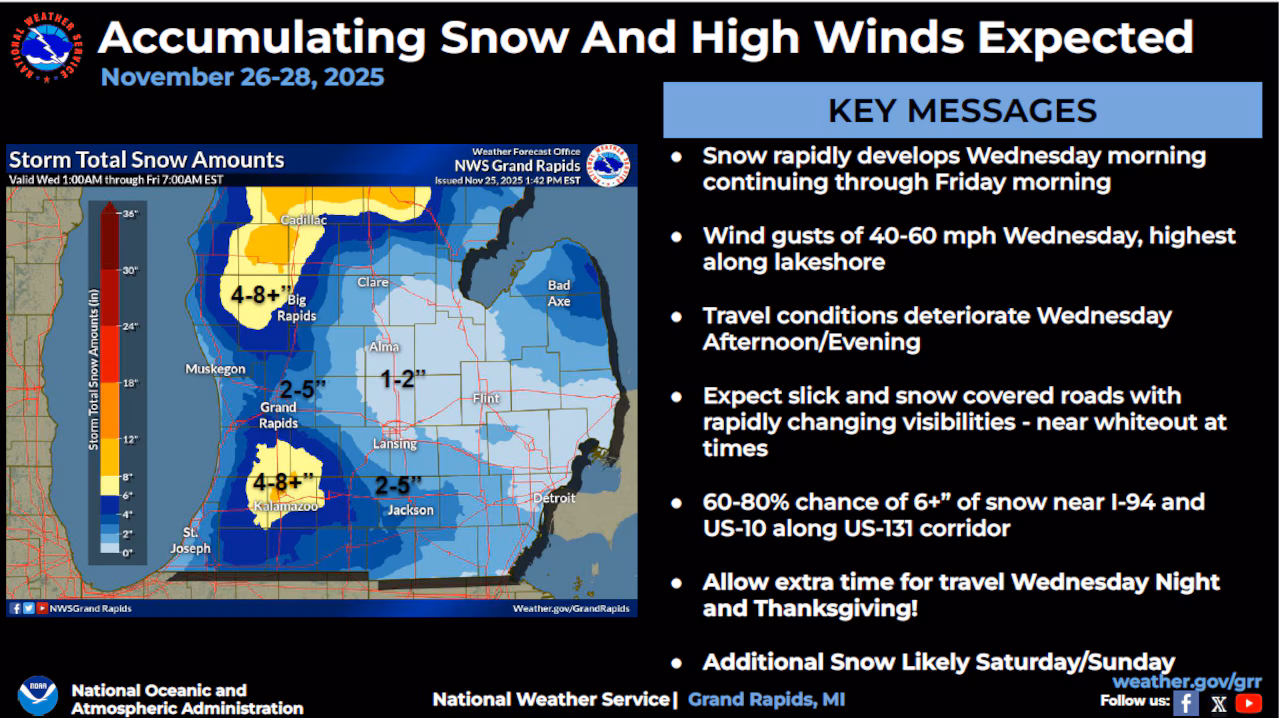
Here are some of Wednesday’s forecast highlights from the NWS:
- Snow rapidly develops Wednesday morning and then continues through Friday morning.
- Wind gusts are forecast to reach 40-60 mph Wednesday, with the highest winds along the Lakeshore.
- Travel conditions will deteriorate Wednesday afternoon/evening.
- Expect slick and snow covered roads with rapidly-changing visibilities – near whiteout at times.
- There is a 60-80% chance of 6+” of snow near I-94 and U.S. 10 along U.S. 131 corridor.
While some areas in the Upper Peninsula are expected to be especially hard-hit by snow – up to 40 inches are forecast for some areas along the Wisconsin border – the Lower Peninsula will see somewhat tamer snow amounts with this storm.
Most of the snow will fall in Northern Michigan, West Michigan and Mid-Michigan, with most areas on the southeast side of the state only getting an inch or two.
In Northern Michigan, up to 12 inches of snow is expected in the snowbelt area from Grayling north to Bellaire.
The NWS says West Michigan will see two areas of high snowfall: The northwest area along and near U.S. 10, and areas southwest of Grand Rapids.
Here are some expected West Michigan snowfall amounts:
- 4 to 8 inches for Mason, Lake, Osceola, Oceana, Newaygo and Mecosta counties.
- 3 to 7 inches: Southwest counties, including Kalamazoo.
- 2 to 5 inches: Muskegon, Ottawa and Kent counties.