- NEXT 12 HOURS: Snow and gusty winds
- SHORT TERM: Still gusty on Thanksgiving
- LONG TERM: More snow this weekend
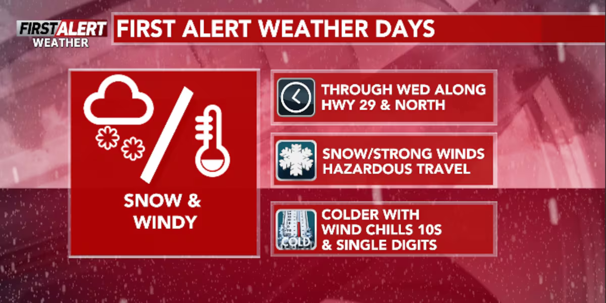
WAUSAU, Wis. (WSAW) – Wednesday will feature our greatest impacts as a result of the snow. This includes the snowfall itself, the gusty winds that will blow the snow around, and that this will be a busy day for travel with Thanksgiving just a day away.
All of north central Wisconsin is under either a Winter Weather Advisory (south of Highway 64), Winter Storm Warning (around Highway 8) or a Blizzard Warning (very far Northwoods) with all advisories or warnings expiring either Wednesday evening or early Thursday morning. Snowfall totals in the far Northwoods (Ashland, Iron, and Vilas Counties) are still slated to pick up over a foot of snow. In fact, a few communities may even pick up over two feet of snow. Snowfall around Highway 8 and just south of the highest snowfall totals could pick anywhere between 6-12” of snow. Highway 64 is looking at about 3-6” still, and then those around Highway 29 and south should pick up 3” of snow or less; most communities should end up with between 1-3” around Highway 29 or Highway 10. Snowfall should stop during the afternoon for those around Highway 29 and Highway 10 first. The further north you are, the longer snow is expected to go on for; snow could continue as late as early Thanksgiving morning off of Lake Superior.
Updated snowfall estimates.(WSAW)
What’s coming up
In addition to the snowfall ranging from moderate to very heavy, very gusty winds will howl across the region. On Wednesday, wind gusts are expected to gust as high as 40-45 MPH or so. On Thanksgiving, wind gusts “calm down” a little to 30-35 MPH at their strongest. Calmer winds are expected heading into this weekend. The wind gusts will greatly reduce visibility as snowfall is taking place (especially where a foot of snow or more could fall up north). Visibility could drop as low as around a quarter of a mile. Our greatest impacts from the wind will come while snow is falling Wednesday morning across all of north central Wisconsin. Visibility should improve greatly after snow stops falling, but blowing snow is still expected on Thanksgiving as well. This will be most prevalent in open areas. Winds will calm down, for real, heading into this weekend.
All warnings and advisories for Wednesday and Thursday.(WSAW)
Not only will the gusty winds affect the road conditions and visibility, but they will also affect the wind chill as well. High temperatures will top out in the mid to upper-20s for most of the region on both Wednesday and Thursday (some of us should have highs in the low-30s early on Wednesday). With wind gusts as strong as they are expected to be, wind chills are expected to hover between 10-20° for both of Wednesday and Thursday with Thursday trending slightly colder. Wind chills are expected to drop into single digits Thursday and Friday mornings.
Gusty winds are expected the next couple of days.(WSAW)
Looking ahead
Just when you thought travel after Thanksgiving would be significantly easier, during this upcoming weekend is when our next chance for snow is expected to arrive. It’s still too early to tell how much snowfall we are going to pick up exactly; although, the further southeast you live will mean the better of a chance you have for higher snowfall accumulations. The majority of the snowfall is looking to take place Saturday afternoon through Sunday morning. Depending on how snowfall totals are trending around this time, we may have to issue a First Alert Weather Day for late Saturday through early Sunday. Stay tuned for more updates on this round of snow as we should have a better idea on this as the snow from Wednesday wraps up.
Super 7 Day Forecast(WSAW)
Click here to download the WSAW News app or our WSAW First Alert weather app.
Copyright 2025 WSAW. All rights reserved.