ORLANDO, Fla. – Right away – the happiest of Thanksgivings to everyone out there!
Mother Nature is doing us a favor and really embracing the holiday, as I hope all of you have too.
Earlier Thursday, you may have noticed some dense fog to start the day in some spots, as well as a band of pretty aggressive rain and wind that quickly swept through northwest to southeast from Marion, Lake, Sumter counties, into Polk and Osceola before evaporating with the bout of dry air coming down behind it.
See that massive trough digging down over the eastern half of the US? That’s what’s driving our temperatures down and near freezing tonight and Saturday before a quick rebound (Copyright 2025 by WKMG ClickOrlando – All rights reserved.)
That was our next big dose of cold, polar air racing in from up north across our state.
Thursday night, we’re watching temperatures do the whole “fall off a cliff” thing once again, as we all celebrate our Thanksgiving and chart our courses for some Black Friday shopping.
I would imagine you can probably set foot outside and already feel that nip in the air. That trademark shift in our air, switching from the subtropical humid blanket we’ve had overhead for a little while now.
Tonight into tomorrow winds are going to increase as high pressure moves in from up north across the state. This will drive our feels like temperatures southward as well (Copyright 2025 by WKMG ClickOrlando – All rights reserved.)
Winds are yet to pick up. There’s a slight lag behind the cold front, given how fast it’s moving towards the southeast. As high pressure starts to build in, digging south from across the Panhandle and Big Bend area into the Central Florida area, that’s when we’ll feel winds begin to rise.
It should be closer to midnight Thursday when we really start to feel the leading edge of that cold layer start flowing through the neighborhood. As winds pick up, the feels like temps will start to drop pretty rapidly for your Friday morning.
As we wake up tomorrow morning, some of us will be pretty close to freezing (Copyright 2025 by WKMG ClickOrlando – All rights reserved.)
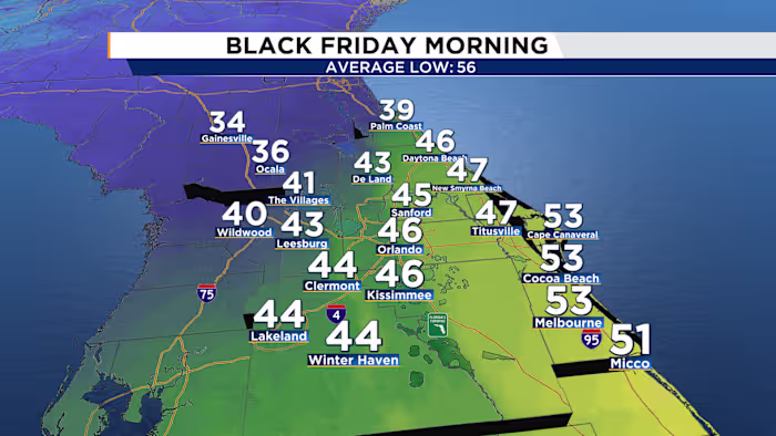
The further north you go, especially for our northwestern viewers, the closer to freezing you’ll feel. There is a freeze warning in effect for Alachua County, so if you’re in the Gainesville area or nearby vicinity, prep for another solid cold wake-up.
The rest of us into Friday morning as day breaks, will wake up feeling near freezing but not as cold as that plunge we experienced earlier this month. From Ocala and the Villages, back east towards Palm Coast, we’ll be close to the 32 degrees Fahrenheit mark.
The Feels Like temps will drop to just below if not right at that freezing threshold, so plan to layer up if you’re back on the road or headed out the door tomorrow morning (Copyright 2025 by WKMG ClickOrlando – All rights reserved.)
The coldest wind chill/feels like temps could bottom out around 33-35 degrees, pending how much we can get those actual winds cranking. So I’m hoping you didn’t pack up all your cold-weather gear from our last big dip in temps to start off the month of November!
Highs are going to fight tooth and nail to reach the mid to upper 60s on Friday, with winds still elevated for most of the day. Layers will be your best friend if you plan to head out with the fam or friends to do some shopping.
Expect plenty of sunshine, clear skies, and cooler fall almost winter-like temps to stick around.
Saturday is expected to be a rerun; however, you’ll see afternoon highs during the mid-day point getting warmer than tomorrow. In fact, by Sunday, it will be as if this cold stint never even took place. I’m calling it a “flash freeze”, if you will.
By that I mean blink, and you’ll miss it!
Saturday highs will start to extend into the mid-70s once more, which is looking pretty good for Florida’s standard. Then on Sunday, the grand finale of November, we’ll be back in the low 80s, almost across the board.
For my cold fans out there, I wish I could say this polar push will hang with us for a bit longer. But for those of you who don’t like these periods of chill, the warmth will return with a vengeance as we enter the final month of 2025 together.
Moving into the first couple of days of December, computer models are pinpointing a developing low pressure area that could take shape near to Texas before quickly wandering eastward towards us driving rain chances much higher (Copyright 2025 by WKMG ClickOrlando – All rights reserved.)
Then we turn our attention to a potential big-time rain event that could be headed our way for the first few days of December, particularly if you’re a north Florida resident.
Computer models are showing a large-scale push of moisture and a developing low-pressure area that could scoot out of Texas towards the east, northeast.
More on that to come, but first let’s battle through this roller coaster of temperatures over the next couple of days!
Copyright 2025 by WKMG ClickOrlando – All rights reserved.