Flood warnings and alerts have been issued as an amber weather warning for rain covers much of south Wales on Monday
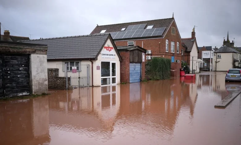
The forecast comes just weeks after residents and businesses were flooded in Monmouth during Storm Claudia(Image: Getty Images)
Over 40 areas of Wales are at risk of flooding after heavy rainfall overnight, with more rain on the way. A rare Met Office amber warning signalling possible “danger to life” in parts of Wales is in force, with nearly a month’s worth of rain forecast to fall in 24 hours.
The warning runs from midnight on Sunday to 11.59pm on Monday and says “fast flowing or deep floodwater is possible, which could cause a danger to life” in the majority of south Wales. Follow our live updates as the miserable weather rolls in here.
As of 6am on Monday morning, over 40 Natural Resources Wales (NRW) flood alerts and warnings are in place across all of Wales.
Two more serious flood warnings are in force River Hydfron at Llanddowror and the River Ely at Peterston Super Ely.
NRW say “immediate action” is required in these areas area, with flooding to some properties expected.
Roads have already began to flood in these areas, the warning states.
40 flood alerts are also in force for rivers and coastal areas. NRW issue these alerts when the risk of flooding is lower but it is possible. For the biggest stories in Wales first, sign up to our daily newsletter here
The body tells locals to expect flooding of low-lying land, minor roads, car parks, recreational land and farmland. There may be spray or wave overtopping at the coast.
Here is the full list of affected areas as of 6am on Monday, December 1:
- Rivers Colwyn and Glaslyn at Beddgelert
- Anglesey catchment
- Upper Dee catchment
- Glaslyn and Dwyryd catchment
- Conwy catchment
- Dyfi catchment
- River Rhymney
- Rivers Ebbw, Sirhowy and Lwyd
- River Cadoxton
- River Thaw
- River Usk in Monmouthshire and Newport
- River Usk in Powys
- River Taff
- Rhondda Rivers
- River Cynon
- River Ely
- River Wye in Powys
- Rivers Wye and Monnow in Monmouthshire
- Rivers Llynfi and Ogmore
- River Ewenny and Vale of Glamorgan west
- Rivers Afan and Kenfig
- Rivers Nant-Y-Fendrod and Nant Bran
- River Neath
- Upper Tawe
- Lower Tawe
- Rivers in Llanelli
- Gower peninsula
- Rivers Loughor and Amman
- Rivers Gwendraeths
- Rivers Bran and Gwydderig
- River Cothi
- Rivers Taf and Cynin
- Upper Towy
- North and west Pembrokeshire
- Western Cleddau
- Eastern Cleddau
- Upper Teifi
- Lower Teifi
- Lower Towy
- South Pembrokeshire
The flood alerts come after significant rainfall overnight, with more rain on the way.
Natural Resources Wales have issued over 40 flood alerts and warnings as of 6am on Monday(Image: Natural Resources Wales)
The Met Office forecast for Monday states: “A murky start for most, as a weather system pushes northeastwards bringing widespread and prolonged outbreaks of rain, with heavy downpours and strong gusty winds likely.
“Conditions worst felt in the south, with coastal gales and flooding possible. Feeling mild. Maximum temperature 13 °C.”
The counties of Blaenau Gwent, Bridgend, Caerphilly, Cardiff, Carmarthenshire, Merthyr Tydfil, Monmouthshire, Neath Port Talbot, Newport, Pembrokeshire, Powys, Rhondda Cynon Taf, Swansea, Torfaen, and Vale of Glamorgan are covered by the amber warning and are set to be worst affected by torrential rain.
Get daily breaking news updates on your phone by joining our WhatsApp community here. We occasionally treat members to special offers, promotions and ads from us and our partners. See our Privacy Notice