West Coast 39°C, Melbourne 16°C. It sounds like a progress score in an AFL or basketball match, but those were the maximum temperatures experienced on a day of huge weather contrasts between the southern tip of Australia’s east and west coasts on the first day of summer.
Melbourne’s maximum to 3pm Monday was actually 16.1°C, which made it the coldest summer day in four years.
The chill in Australia’s southeast was caused by a cold front which injected polar air across much of Victoria and southern NSW. Snow fell heavily at times in the high country with the mercury remaining below zero through daylight hours at Mt Hotham (Vic) and Thredbo (NSW).
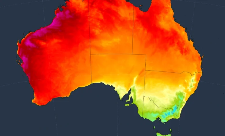
On the opposite side of the country, air circulating anti-clockwise around a high pressure system caused a large pool of hot air to be pushed towards western and northwestern Australia.
The heat across the country’s SW corner was widespread on Monday.
- Albany Airport – just over 400km SE of Perth in the relatively cool South Coastal forecast district – reached 36.1°C.
- Geraldton – just over 400km NW of Perth, endured a sizzling 42.2°C start to the 2025/26 summer.
- Perth itself had a maximum of exactly 39°C to 3pm Monday, while some suburbs topped 40°C.
Image: Synoptic chart for Monday, December 1, 2025 showing air circulating anti-clockwise around the high, bringing very cool air to the southeast and hot air to the southwest.
As Weatherzone meteorologist Ben Domensino wrote on Monday afternoon, the hot air that is baking WA on Monday will spread east during the week as the high pressure system drifts over southeastern Australia and eventually off the country’s east coast.
Melbourne should warm up to as much as 33°C on Thursday, while Perth’s maximums will drop into the 20s for the rest of the week as winds shift to a southwesterly direction.