A Trace to 3 Inches of Snow for Parts of Maryland and Northern Virginia Expected By National Weather Service
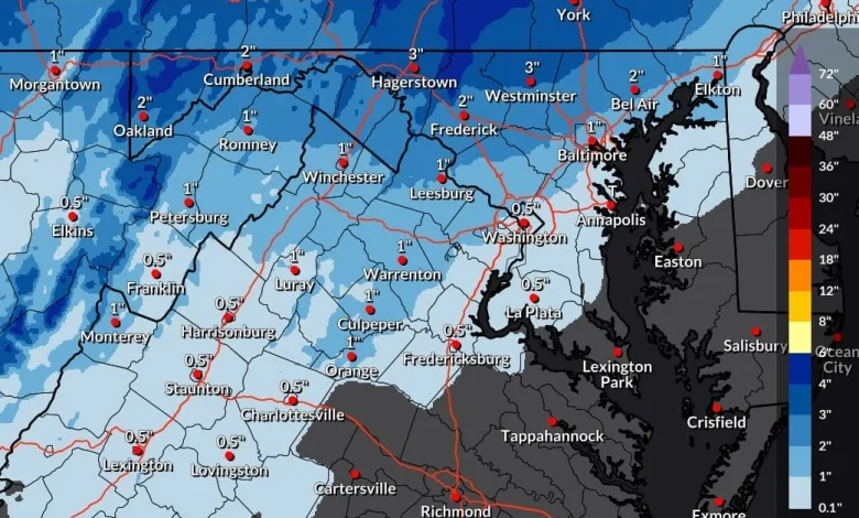
The National Weather Service (NWS) has released its latest snowfall projections for a storm headed towards us on Tuesday morning, showing totals ranging from a trace to as much as three inches across the Washington, DC.
Most of the immediate metro area, including Washington, DC, Montgomery County, and Prince George’s County, is currently forecast to receive between a half inch of snow and up to two inches in areas like Damascus. Higher totals are expected farther northwest, where areas such as Frederick, Westminster, and Hagerstown could see between one and three inches, with the highest amounts near the Maryland-Pennsylvania border.
The NWS “High End Amount” map, which reflects a one-in-ten chance scenario, indicates the potential for higher totals if the system overperforms. Under this outlook, parts of Carroll County and Frederick County could reach four to five inches, while most of Montgomery County remains closer to one to two inches. The “Low End Amount” map shows no snow for most of the region.
The NWS also released an updated probability map showing the percent chance of receiving at least one inch of snowfall. Frederick and Carroll counties fall between 39 and 51 percent. Montgomery County’s chances generally range from 21 to ~50 percent (Damascus area), with the higher probabilities in the northern part of the county. The immediate DC area, including Arlington, Alexandria, and Prince George’s County, shows a 10 to 20 percent chance of reaching an inch, while southern Maryland and Annapolis remain under 10 percent.
Overall, the projections point to light accumulations for most of the DC region, with the best chance for measurable snow concentrated northwest of the Beltway. FOX5’s Mike Thomas writes, “First winter related school delays & closures of the year in some spots? Perhaps!”
It’s important to remember that all snow that falls may not stick and this is likely to change over to rain. If the winter weather lasts longer, it can certainly have an impact on the Tuesday morning commute. We’ll continue to monitor and release our first pencil prediction of the season tonight or tomorrow.
Courtesy National Weather Service
Courtesy National Weather Service