(WLOS) — Tonight and early Tuesday morning will bring slick travel conditions to parts of western North Carolina.
A storm system moving up from the Gulf Coast is bringing a cold, soaking rain, with some pockets of freezing rain leading to icy spots on roads.
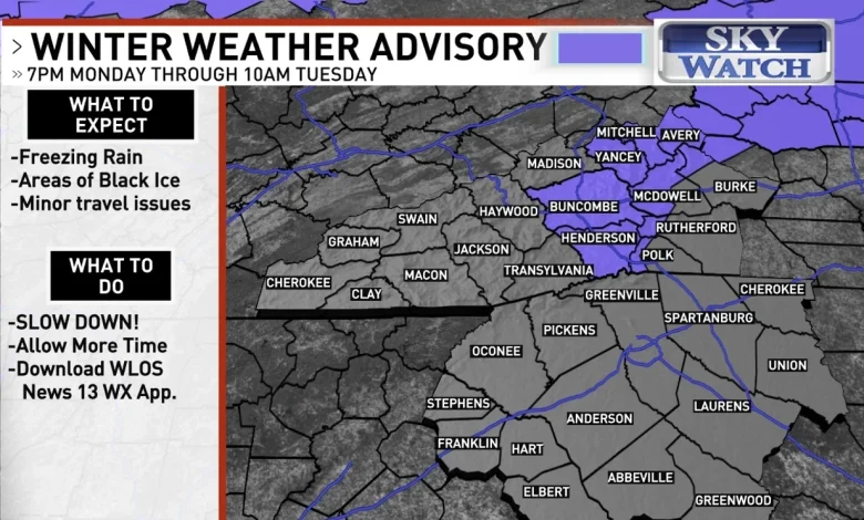
There is a potential for icy conditions in parts of WNC on the morning of Dec. 2, 2025. (WLOS)
The National Weather Service has issued a Winter Weather Advisory for freezing rain that begins at 7 p.m. Monday and continues until 10 a.m. Tuesday.
WNC FACES CONSECUTIVE CODE PURPLE NIGHTS; SHELTERS OPEN FOR THOSE IN NEED
This advisory includes Avery, Buncombe, Henderson, Mitchell and Yancey Counties, plus the Burke, McDowell, Polk and Rutherford Mountains. Folks in the advisory area should limit travel due to black ice.
People who need to be on the roads are advised to slow down and take extra time to get to their destinations.
HOW MUCH WILL IT SNOW IN ASHEVILLE? SEE NEWS 13’S WINTER WEATHER OUTLOOK FOR 2025-26
By midnight, higher elevations, including some outside of the Winter Weather Advisory, could be slick.
Temperatures are expected to rise slightly during the overnight, with most locations being above freezing by 7 a.m. on Tuesday.
The futurecast for 7 a.m. on Tuesday, Dec. 2. (WLOS)
Most of the ice accumulation will be very light.
Some locations in the northern mountains, like Burnsville and Mt. Mitchell, could get up to a tenth of an inch of ice.