PORTLAND (WGME) — Maine is gearing up for its first significant snowstorm of the season.
Here are some of the highlights for Tuesday’s storm:
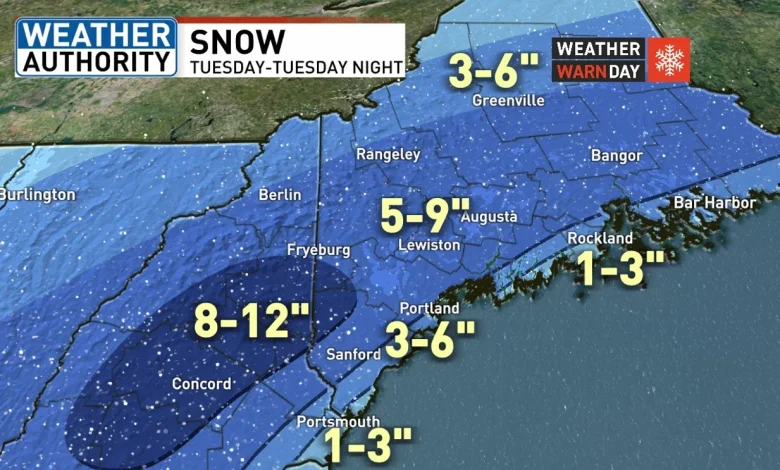
SNOW TUESDAY THROUGH TUESDAY NIGHT
- TIMING: Snow starts 7AM to 9AM Tuesday. Snow ends 1AM to 3AM Wednesday.
- TYPE: All snow inland. Snow mixes with rain coast.
- HOW MUCH: 5-9″ for most of the area. 3-6″ at the coast. Jackpot of 8-12″ Central NH to far western Maine. See map below
- WIND: Light east to northeast winds Tuesday. Northeast to North winds increasing 15 to 20 MPH Tuesday night.
Most of the region should pick up 5-9″ of snow. Some rain is expected to hold totals down near the coast.
Winter Storm Warning’s and Winter Weather Advisories have been issued 8AM Tuesday through 4AM Wednesday.
Snow should get going between 7 a.m. and 9 a.m.
Charlie_GRAF_StormTracker.png
Rain is expected to hold totals down at the coast.
Charlie_GRAF_StormTracker.png2.png
Areas receiving rain near the coast should experience a change to snow evening and night.
Charlie_GRAF_StormTracker.png3.png
Skies will be clearing Wednesday morning setting the stage for a nice day mid-week.
The passage of an artic cold front will be the big weather story late Thursday.
A snow shower or squall is possible.
More importantly, a very cold air mass will settle in Thursday night into Friday.
Highs Friday will have a hard time getting out of the teens.
Another round of light snow is possible Saturday.
Comment with Bubbles
JOIN THE CONVERSATION (28)
Stay tuned!