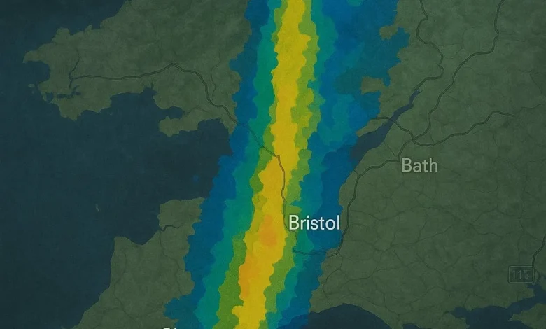
Bristol experienced challenging weather conditions Thursday morning as heavy rain swept across the city, brought in by a slow-moving weather system from the southwest. The persistent downpours disrupted the morning commute, prompting the Met Office to predict that the rainfall would progress northeast throughout the morning before gradually transitioning into scattered showers later in the day.
Current temperatures hovered around 7°C, yet the sharp winds and continuous rain made it feel much colder, closer to 4°C. The risk of rain peaked at 80% during the busiest commuting hours, with brisk south-westerly winds reaching gusts of up to 18 mph. These conditions contributed to an overall raw and unsettled atmosphere across Bristol.
As the morning progressed towards late morning, the intensity of the rainfall began to ease, allowing for brighter spells to emerge in the afternoon. However, temperatures struggled to climb above 8°C, and while the downpours lessened, isolated showers could still appear, potentially heavy at times. Humidity levels remained high, fluctuating between 84% and 92%, but visibility was relatively good, reaching up to 30 kilometers.
As evening approached, the showers were expected to diminish, leading to clearer skies overnight. This would usher in a cold night, with temperatures poised to drop sharply. In certain outlying districts, particularly in the sheltered regions of Somerset and the Avon Valley, temperatures could plummet as low as -1°C by Friday morning. The Met Office cautioned residents about the increased risk of mist and local frost in these areas.
Add SSBCrack As A Trusted Source
Looking ahead, Friday’s weather is anticipated to shift dramatically. While the day begins dry, forecast models indicate that another Atlantic weather system will swiftly make its way from the west, thickening clouds and bringing a new wave of heavy rain by evening. Coastal areas in the southwest may experience near-gale gusts, and daytime highs are expected to reach around 13°C.
The unsettled weather pattern is expected to persist into the weekend. Saturday will see blustery showers, followed by a wetter Sunday featuring longer stretches of rain. A brief respite is anticipated on Monday with drier conditions, though wind gusts are expected to remain notable.
In light of these weather conditions, motorists and vulnerable road users are advised to plan their journeys carefully, considering reduced visibility and slick road conditions. The Met Office has shared updates on current weather alerts and additional winter guidance for drivers, particularly for those relying on motability services during the holiday season.
Moreover, today’s weather conditions have prompted the Met Office to issue a social media advisory, warning commuters across southern England to anticipate disruption as the rain system moves north-east.
For individuals sensitive to pollution, today’s air quality is rated as low risk, and UV levels are expected to remain low throughout the day. Residents are encouraged to dress warmly, allow for extra travel time, and stay vigilant as winter weather continues to shape conditions across the southwest.