Brrrr!! It’s going to be wicked cold in Maine to end the week.
A passing Arctic front is set to bring snow showers, snow squalls and very cold wind chills to the region.
Look for lots of clouds with air temperatures in the 30s.
Feel-like temperatures throughout the day will be running in the 20s.
Thursday morning.{ }(WGME)
It’s important to note that not every town will receive snow.
Snow squalls set to start towards the international border.
Thursday afternoon.{ }(WGME)
By lunchtime, snow showers and squalls will be closer to major highways and routes at the coastline.
Within any squall, there will be a brief period of heavy snow and strong winds.
Make sure to turn your lights on if caught in one and slow down, don’t slam your brakes immediately.
Along with snow showers and or squalls comes the wind.
Winds will increase throughout the afternoon heading into nighttime hours from the west shifting northwest. Look for gusts up to 30 to 40 MPH as temperatures fall into the teens early in the night.
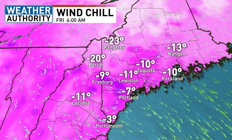
This will send nighttime wind chills into the negatives for most of us.
Look for brighter skies, much lighter winds, yet cold temperatures for Friday.
By Friday morning, feel-like temperatures will be in the negative double digits. Most of us will have a difficult time getting out of the low 20s.
Clouds thicken up on Saturday with the possibility of a few flurries and light snow showers. Not much accumulation will be expected.
Get ready for more cold temperatures early next week.