Arctic weather blast will bring snow squalls to Massachusetts. Maps show how cold it will get.
No rest for the winter weary after the first significant snow of the season fell in Massachusetts on Tuesday. The weather forecast shows an early-season Arctic blast is on the way to the Boston area.
A cold front will pass through New England Thursday afternoon, ushering in the coldest air since last winter.
There will be a few scattered snow squalls along the front which could briefly whiten the roads anytime between 2 p.m. and 7 p.m.
After the front passes through, the frigid air immediately pours in. Temperatures will drop from daytime highs in the 30s to the single digits overnight.
CBS Boston
At the same time, we will get about 12 hours of very gusty northwest winds. Peak gusts, mainly between 20-40 mph, will occur from late afternoon through the early hours of Friday morning.
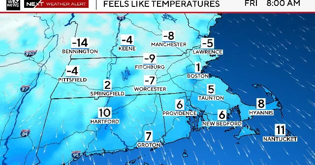
Combine the winds with the tumbling temperatures and you get feels-like readings between -10 and 10 degrees Thursday night.
CBS Boston
It will be absolutely frigid at the bus stop Friday morning.
Temperatures will range from the teens over southeastern Massachusetts to slightly below zero north and west of Boston.
The winds will be decreasing at that point but still enough to add an extra bite to the air.
CBS Boston
We will spend the entire day Friday below freezing with highs in the 20s throughout most of southern New England.
We will rebound into the mid 30s by Saturday, still about 10 degrees below the average.
It appears as though this may be just the first in a series of bitterly cold shots in the next 7-10 days. We are likely to get another blast of cold on Monday and perhaps a third around the end of next week