WASHINGTON – Tuesday morning went according to the forecast here in DC, a bit of a wintry mess in the area leading to school delays, some light accumulations in far northwest areas…but impacts that did not last. If you step outside this evening, it certainly still feels like the heart of winter, Tuesday’s storm did not leave any snow behind to show for it. Could another, perhaps better opportunity for snow come later this week?
Tuesday’s Run Of The European Model, Showing Possible Snow in DC on Friday
Yes! Or rather…it is possible. Weather models are hinting that more winter weather may brush the Washington, DC region on Friday as a developing system swings along the Mid-Atlantic. While the atmospheric setup does have the attention of Fox 5 meteorologists, the threat for accumulating snow remains highly uncertain even with the threat just a few days away. The range of potential outcomes is unusually wide for a short-range forecast.
Friday Will Likely Be The Coldest Day Of The Week Following An Arctic Cold Front Passage On Thursday
While the threat for snow is still a bit uncertain, one thing that is not is whether or not it will be cold enough to snow. A strong, arctic cold front will pass the region on Thursday. Along it, some Great Lakes moisture could get carried into western parts of our region, and we cannot rule out a few snow flurries as this burst of even colder air enters the DC region on Thursday night. Cold air will remain in place heading into Friday, with 20s to start the day and highs struggling in the 30s during the afternoon. Those temperatures certainly open the door for wintry weather, but exactly how the system behaves will determine whether the area sees actual snowfall or just cold, but dry conditions.
Why the forecasts disagree: Atmospheric tug-of-war
Two Most Likely Scenarios For Fridays System Involve A Turn Up The Coast, Or A Slide Out To Sea
Small changes, big differences | Different models, different outcomes
Weather forecasters rely on a host of weather prediction models to help predict the development and movement of storms. There are many, including ones in the modern era that are enhanced by artificial intelligence. We could write going over each model and its possible solution, but we will focus on the two most common and famous ones here, the classic American and European models.
The Position Of An Upper Trough Swinging Through The Eastern Half Of The Country Friday Into Saturday Is Key To Any Potential Accumulating Snow In Our Region
There is a key to this potential storm and what it could bring the DC region, and that is an upper trough, essentially a dip in the northern jetstream. If you are rooting for snow, you want this feature to be stronger, and diving southward. The reason why is that when a developing storm interacts with a northern trough, the upper-level winds help amplify and strengthen the storm, allowing it to grab more moisture as it strengthens. The direction of these winds are also key, as it helps direct the storm up the East Coast.
What a lot of models are suggesting is that this feature will not be too amplified. If this is the case, instead of a storm that tracks up the coast and intensifies, you can get a much weaker wave that passes south of the DC region, leaving us snow free.
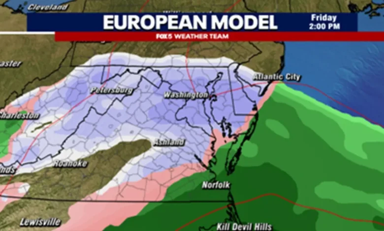
European Model Projection for Friday Afternoon, Showing Snowfall In The DC Region
European model
The most aggressive model with snowfall at the moment is the European model, which does show the storm interacting with the trough and strengthening enough that is does overspread the DC region will snowfall on Friday afternoon through the evening hours.
Now, despite how aggressive the above image looks, it is not putting down a lot of snow locally because the trough never really captures and amplifies the storm to its full potential. The raw data suggest mostly 1-3″ would be possible in our region…far from any major snowstorm.
The Latest American Model Data, Showing A Much Weaker Storm Passing To The South
American model
In a situation like Friday, it is often the American Model that shows a snowier solution. This time around though, the American model has been suggesting that the pieces will not come together to develop a stronger system. The system that develops ends up strengthening very little, and with no interaction with the upper trough, it “slides” rather harmlessly out to sea to our south, leaving the DC region dry, but still very cold.
While historically, the European model has tended to be the more accurate one at this range, we are leaning a little more with the American model this time around. It is showing better agreement with both the European and American Artificial Intelligence models which also suggest a miss of the storm to the south as of Tuesday night. Even on the European model, our concern is that the weather pattern that is shown across not the eastern half of the country, but the western half of the county, is not conducive to helping a storm develop and push up the East Coast.
So what do we think will happen?
While the chance for snow is a possibility on Friday, we are leaning more towards a miss to the south than a impactful snowfall for the DC region at this time. I believe the European model will likely shift southward in the days ahead.
Can this change? Certainly. But for that to occur you will need a stronger upper-level ridge, essentially a northward bump in the jetstream across the western United States, to start showing up in weather models very quickly. This would help amplify the dip in the jetstream in the eastern half of the country, and likely lead to a stronger storm. As the strong model consensus is against this happening, we feel we are unlikely to see this change in the next couple of days.
Any other threats in the near future?
NOAA Extended Outlook Shows High Likelihood Of Cold Remaining In The East Through At Least The Middle Of The Month
So if we miss out on Friday’s threat of winter weather, are there anymore threats heading our way? Well one thing we are quite confident of is that the cold air that has been in place since the Thanksgiving holiday looks like it is sticking around for the foreseeable future. Models do remain quite active with the pattern as well. While there are no clear, impactful snow threats beyond Friday’s rather doubtful chance showing up in the models at this stage, several do hint at the potential for some clipper systems to impact the region next week. It is always difficult to nail down a snow threat in the extended range though, as jetstream interaction is so key, and weather models are constantly shifting it in the extended range.
We will continue to keep you updated as new threats emerge. With a cold and active pattern though, we do anticipate that at some point next week, we will likely have another shot at some wintery weather passing by the DC region. Just too early to know how all the pieces will come together for how they could potentially impact us. Stay tuned!
The Source: Information in this article comes from the FOX 5 Weather Team and the National Weather Service.
WeatherNewsWashington, D.C.VirginiaMarylandWinter WeatherTop Stories