A forecast map from the National Weather Service (NWS) shows which states can expect the coldest conditions, with a fresh arctic blast expected this weekend.
“Another shot of arctic air is on the way for next weekend (December 12-14) across the northeastern quadrant of the United States,” the NWS forecast office said in a post on X on Sunday.
“Wind chills may drop below zero, especially during the overnight hours,” the NWS added.
The agency also said that high temperatures could fall toward the single digits and teens, with lows potentially dropping toward zero.
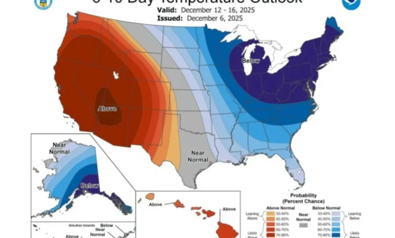
According to a forecast map shared by the agency, the states with the highest probability of seeing below average temperatures between December 12 and December 16 are:
- Maine
- New Hampshire
- Vermont
- Massachusetts
- Rhode Island
- Connecticut
- New York
- Pennsylvania
- New Jersey
- Delaware
- Maryland
- Virginia
- West Virginia
- Ohio
- Kentucky
- Indiana
- Illinois
- Michigan
- Wisconsin
Meteorologists previously said that multiple waves of Arctic air associated with the polar vortex will hit the U.S. through mid-December.
Forecasters at AccuWeather previously said the first of these waves—forecast to surge south out of Canada into the Plains, Midwest and Northeast through midmonth—moved south and east through Thursday night.
“The second blast of Arctic air is expected to advance from the northern Plains today to the Midwest on Sunday and then to the East on Monday,” AccuWeather meteorologist Dan Pydynowski told Newsweek on Saturday.
“Temperatures across many areas of the Midwest could drop below zero Fahrenheit on Monday morning, roughly 15 to 25 degrees below the historical average. For example, we are forecasting a low of -3 F in Madison, Wisconsin Sunday night/early Monday morning,” Pydynowski added.
“Yet another round of Arctic cold looks to dive southward into the northern Plains on Wednesday December 10 and then progress south and east through the upcoming weekend, December 13-14,” the meteorologist said.
Pydynowski added at the time that the coldest days for the Northeast and mid-Atlantic will be Saturday the 13th and Sunday the 14th, with temperatures in the afternoon possibly struggling to reach freezing both of these days in New York City.
“This third blast looks a little colder and more prolonged than the blast we are dealing with today through Monday,” Pydynowski said.
The polar vortex is a persistent pool of low pressure and frigid air around the poles that weakens in summer and strengthens in winter, according to the NWS. Its counter-clockwise winds usually keep cold air contained, but in Northern Hemisphere winters it can expand and push Arctic air south with the jet stream, often triggering U.S. cold outbreaks.
For local forecasts, regional NWS branches issue local updates frequently via the agency’s website and social media channels.