PORTLAND (WGME) — Almost everyone woke up on Tuesday morning to temperatures in the negatives. Portland’s record low for December 9th is -6 degrees set back in 1949.
We’ll know just how cold Portland got when the report comes out from NWS Gray. Stay tuned.
The coldest air so far this season was with us before a few rounds of wintry weather joins us in the near-future.
For much of the day on Monday, air temperatures will be running near the low-to-mid 20s with feel-like temps (wind chill values) in the teens.
Overnight Tuesday.{ }(WGME)
Sun will be on tap to start the day, before clouds increase in the afternoon.
A weak system will bring some light snow overnight to the area.
Snow overnight Tuesday into Wednesday.{ }(WGME)
Most of us receiving a dusting to possibly an inch towards the Midcoast.
Downeast Maine may see up to 2 inches.
Wednesday midday.{ }(WGME)
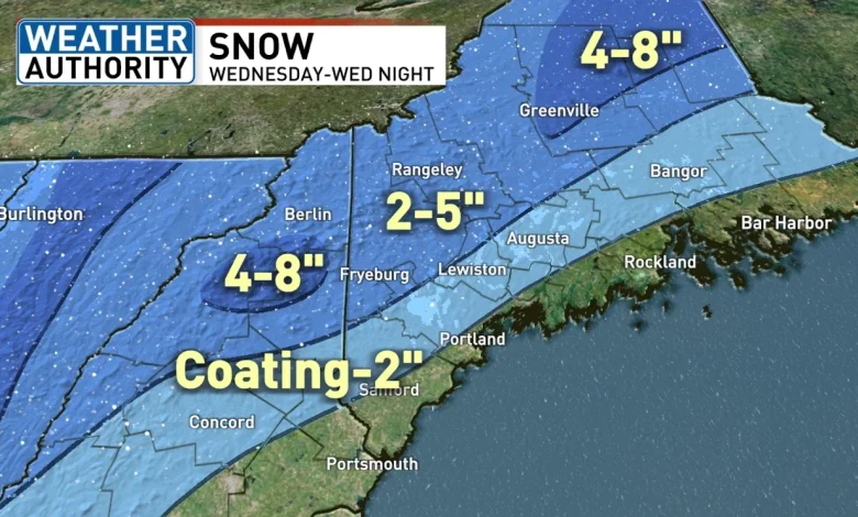
Wednesday will be our next weather-maker during the early afternoon and overnight hours.
Precipitation will begin as snow at the coast before switching over to rain for the majority of the afternoon/evening.
Wednesday afternoon.{ }(WGME)
Inland spots will receive snow before mixing with rain, causing a slushy mess for the evening commute.
In the mountains, they will stay mostly snow and accumulate some too. 2 to 5 inches could be expected.
Sun and wind will end out the week for us with another cold weekend ahead.
Comment with Bubbles
BE THE FIRST TO COMMENT