Severe thunderstorms to bring large hail, damaging winds and heavy rainfall to parts of New South Wales and Victoria this weekend, and a strong cold front could bring damaging winds and Extreme Fire Dangers to Tasmania. So let’s look at all of that in more detail.
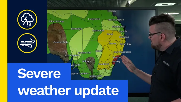
Firstly, today’s thunderstorm map. Now, we saw heavy thunderstorms this morning around the Central Coast and the Sydney area. And we saw heavy falls of 30 to 50 mm in just one hour around the Warragamba Dam area. We also saw heavy falls on the Central Coast in that 50 to 80 mm mark. Now we’re likely to see widespread severe thunderstorm activity today, anywhere from southern inland Queensland, around Roma, through Moree, Byron Bay, Port Macquarie, Dubbo, Canberra and even into far northern Victoria today. Anywhere in this yellow highlighted area has the potential to experience large hail, damaging winds and heavy rainfall with thunderstorms, and we’re likely to see further severe thunderstorms around that Central Coast area in this red highlighted area, with storms also expected across much of Queensland and eastern parts of South Australia. But let’s have a look at all of that in more detail.
So we saw that heavy rain and thunderstorms through Sydney this morning. But notice by the late afternoon hours we’re seeing widespread thunderstorm activity from the Darling Downs area of Queensland, much of eastern New South Wales and even into eastern parts of Victoria. And, as I mentioned earlier, many of these storms could bring that heavy rain, large hail and damaging wind risk. The highest risk is in north-east New South Wales. Then, as we move into the evening hours, note those storms quickly dissipate through parts of New South Wales as they contract into north-east New South Wales and south-east Queensland. But then our eyes will cast westwards to this surface trough through parts of South Australia and Victoria, and that’s going to be the focus for our weather on Saturday.
So looking at the storm map on Saturday, we’re going to see that focus of severe thunderstorms move inland towards much of inland New South Wales and northern and north-eastern Victoria, with thunderstorms also likely through Melbourne and much of north-eastern Tasmania as well. But do notice that through parts of south-east Queensland and north-east New South Wales and the eastern parts of New South Wales should have a much quieter day on Saturday. But those in this yellow highlighted area could see another round of large hail, damaging winds and heavy rainfall.
So looking at that in more detail, Saturday is going to start off a bit differently as we see that shower and thunderstorm activity develop in the early morning hours on Saturday morning through north-west Victoria, eastern South Australia and south-west New South Wales, with some storms starting to develop through northern Tasmania as well. Then as that trough moves eastwards into more moisture, we’ll see widespread thunderstorm activity develop in the early afternoon hours through inland New South Wales, central and eastern Victoria and also eastern parts of Tasmania as well, and that could be a concern there with some of our ongoing fires so we’ll be watching that on Saturday. And, as I mentioned, inland New South Wales could see those storms with large hail, damaging winds and heavy rainfall.
But then as we move into the Saturday evening hours, we’ll notice those storms move eastwards but then weaken as they approach the east coast. Still could be pretty wet and stormy though around the Canberra and Sydney area into the afternoon and evening hours. Then, that will all clear out for much of the south-east, and then our focus shifts to north-east New South Wales and Tasmania on Sunday, as we see a strong cold front bringing cooler air and drier air to much of South Australia and Victoria, and then pushing that storm focus into north-east New South Wales, where we could see severe thunderstorms there with widespread thunderstorms through southern inland Queensland, and also our strong cold front through parts of Tasmania we’ll be watching as well.
So, as we move through Sunday, that strong cold front will sweep across Tasmania on Sunday and that’s going to bring damaging winds, possibly for elevated areas, and also possibly drive Extreme Fire Dangers through eastern parts of Tasmania where we do have those ongoing fires. So it’s going to be wet and windy on the west coast, dry and windy on the east coast, so we’ll be watching those fires closely. Much quieter day for inland south-east Australia, just apart from that severe storm risk in north-east New South Wales.
So with all this weather going on, how much rainfall are we going to see over the coming days? Well, most of this rainfall on the east coast is going to fall today with another 10 to 20 mm, isolated falls up to 50 mm possible. More widespread soaking rain through north-eastern New South Wales with that storm activity over a few days where we could easily see 30 to 50 mm, and isolated falls up to 100 mm possible, and also pretty wet through western Tasmania as well with those cold fronts, but unfortunately very little if any rainfall through eastern Tasmania, where we do have those ongoing fires.
So, with severe thunderstorms in New South Wales and Victoria, strong winds, damaging winds and extreme fire dangers in Tasmania, there’s a lot of weather going on around the country this weekend, so make sure to stay up to date with the latest forecasts and warnings for your area via our website and app and you can always listen to all advice from emergency services.