ROCHESTER, Minn. (KTTC) – A blast of cold Arctic air is still expected to impact the upper Midwest this weekend. High temperatures could stay below 0° on Saturday!
Saturday:
Saturday morning wind chills(KTTC)
Wind chills Saturday morning will range from -15 to -25 across SE MN and NE IA. The NWS has issued Cold Weather Advisories for counties along and north of Highway 14. Cold conditions will continue throughout the day.
Hourly wind chills on Saturday(KTTC)
Wind chills will stay around -15 to -25 degrees all day long on Saturday. After 6-7 p.m., wind chills will drop to around -25 to -30 in some locations.
Sunday’s Wind Chills:
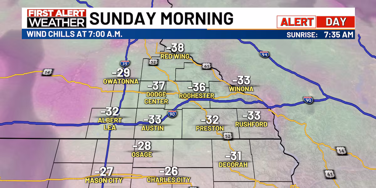
Sunday morning wind chills(KTTC)
Wind chills Sunday morning could range from -25 to even -40 degrees in some locations.
Sunday’s outlook(KTTC)
Wind Chills will improve by the late afternoon on Sunday. Wind chills by then will be around -10 to -15 degrees. Be safe if you’re outside Sunday morning!
Long-term temperature outlook(KTTC)
The long-term temperature outlook is trending warm across most of the country. The Climate Prediction Center gives the upper Midwest a 40-50% of above-average temperatures from the 19th through the 25th.
And we’ll see above-average temperatures as early as next week (Tuesday through Thursday)!
White Christmas tracker(KTTC)
It might be hard to believe, but our chances of a white Christmas aren’t extremely high. Our snow depth sits at 7″ at RST. Right now, I give us about a 70% chance of still having 1″ of snow on the ground by Christmas. However, if long-range temperature trends continue to hint at above-average temperatures, our chances of a white Christmas will decrease!
10-day forecast(KTTC)
Nick
Find stories like this and more, in our apps.
Copyright 2025 KTTC. All rights reserved.